
User guide


March 2005 Designing Your Canopy Network
Through Software Release 6.1
Page 108 of 425 Issue 1
Canopy System User Guide
Topographic maps with waypoints are available from sources such as the following:
◦ http://www.topografix.com
− TopoGrafix EasyGPS
− TopoGrafix Panterra
− TopoGrafix ExpertGPS
Topographic images are available from sources such as the following:
◦ http://www.keyhole.com/body.php?h=products&t=keyholePro
− keyhole PRO
◦ http://www.digitalglobe.com
− various imagery
12.4.2 Surveying Sites
Factors to survey at potential sites include
◦ what pre-existing wireless equipment exists at the site. (Perform spectrum
analysis.)
◦ whether available mounting positions exist near the lowest elevation that satisfies
line of site, coverage, and other link criteria.
◦ whether you will always have the right to decide who climbs the tower to install
and maintain your equipment, and whether that person or company can climb at
any hour of any day.
◦ whether you will have collaborative rights and veto power to prevent interference
to your equipment from wireless equipment that is installed at the site in the
future.
◦ whether a pre-existing grounding system (path to Protective Earth) exists, and
what is required to establish a path to it.
◦ who is permitted to run any indoor lengths of cable.
12.4.3 Assuring the Essentials
In the 2.4-, 5.2-, 5.4-, and 5.7-GHz frequency band ranges, an unobstructed line of sight
(LOS) must exist and be maintainable between the radios that are involved in each link.
Line of Sight (LOS) Link
In these ranges, a line of sight link is both
◦ an unobstructed straight line from radio to radio.
◦ an unobstructed zone surrounding that straight line.
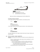
Fresnel Zone Clearance
An unobstructed line of sight is important, but is not the only determinant of adequate
placement. Even where the path has a clear line of sight, obstructions such as terrain,
vegetation, metal roofs, or cars may penetrate the Fresnel zone and cause signal loss.
Figure 39 illustrates an ideal Fresnel zone.