
User's Guide
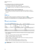
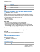
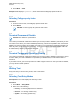
Table Of Contents
- Contents
- List of Figures
- List of Tables
- Declaration of Conformity
- Safety Information
- Notice to Users (FCC and Industry Canada)
- Copyrights
- General Information
- Getting Started
- 2.1 Product Technical Information
- 2.2 Before Power On
- 2.3 Controls and Indicators
- 2.4 Display
- 2.5 Status Icons
- 2.6 Powering On the Radio
- 2.7 PIN Code Authentication
- 2.8 Locking or Unlocking the Keys or Buttons
- 2.9 Holding Your Radio
- 2.10 High or Low Audio Toggle
- 2.11 During a Call
- 2.12 Entering TMO or DMO Mode
- 2.13 Selecting Talkgroups
- 2.14 One-Touch Buttons
- Modes
- 3.1 Trunked Mode Operation
- 3.1.1 Entering TMO Mode
- 3.1.2 Making Group Calls in TMO
- 3.1.3 Receiving Group Calls in Idle
- 3.1.4 Receiving Group Calls during Ongoing Group Calls
- 3.1.5 Dynamic Group Number Assignment (DGNA)
- 3.1.6 Broadcast Call
- 3.1.7 Phone and Private Automatic Branch Exchange (PABX) Calls
- 3.1.8 Assistance Call
- 3.1.9 Call Modification
- 3.2 Local Site Trunking
- 3.3 Direct Mode Operation
- 3.3.1 Entering DMO Mode
- 3.3.2 Making Group Calls in DMO
- 3.3.3 Receiving Group Calls in Idle
- 3.3.4 Selecting DMO Communications Options
- 3.3.5 DMO Private Priority Call
- 3.3.6 Talkgroup for Individual Calls
- 3.3.7 Network Monitor
- 3.3.8 Communication through Repeaters
- 3.3.9 Communication through Gateways
- 3.3.10 Gateway and Repeater Synchronization
- 3.4 Transmit Inhibit Mode
- 3.5 Emergency Operations
- 3.5.1 Emergency Alarm
- 3.5.2 Emergency Group Call
- 3.5.3 Non-Tactical Emergency
- 3.5.4 Emergency Individual Calls (Private or MSISDN)
- 3.5.5 Emergency SDS Status
- 3.5.6 Emergency Hot Microphone
- 3.5.7 Alternating Hot Microphone
- 3.5.8 Silent Emergency Mode
- 3.5.9 Invisible Emergency
- 3.5.10 Emergency Alert
- 3.5.11 Disaster Alert
- 3.5.12 Exiting Emergency Operations
- 3.6 Repeater Mode
- 3.1 Trunked Mode Operation
- Main Menu
- 4.1 Scrolling through the Menu
- 4.2 Menu Icons
- 4.3 Messages
- 4.4 Contacts
- 4.5 Bluetooth
- 4.6 Browser
- 4.7 Man Down
- 4.8 Security
- 4.9 Setup
- 4.10 Group Setup
- 4.11 Individual Setup
- 4.12 Favorites
- 4.13 My Info
- 4.14 Recent Calls
- 4.15 Shortcuts
- 4.16 Networks
- 4.17 Location
- 4.18 Packet Data
- 4.19 Crypto Menu
- Features
- 5.1 Ambience Listening (AL) Call
- 5.2 Bluetooth
- 5.3 Buffer Full Overwrite Policy
- 5.4 Call-Out
- 5.5 Collaborative Messaging
- 5.6 Global Navigation Satellite System (GNSS) Location Service
- 5.7 Home Display Text Message
- 5.8 One-Touch Dial
- 5.9 MS-ISDN
- 5.10 Private Call
- 5.11 Phone and Private Automatic Branch Exchange (PABX) Calls
- 5.12 Phone/PABX Speed Dial
- 5.13 Radio Messaging System (RMS)
- 5.14 Radio User Assignment (RUA) and Radio User Identity (RUI)
- 5.15 SIM Card End-to-End Encryption
- 5.16 Short Number Dial
- 5.17 Talkgroup Dialing by Index
- 5.18 Terminal Permanent Disable
- 5.19 Terminal Temporary Disable or Enable
- 5.20 Writing Text
- 5.21 Wireless Application Protocol (WAP)
- 5.21.1 WAP Browser
- 5.21.2 Entering the Browser
- 5.21.3 Entering Browser Menu Panes
- 5.21.4 Tips for Browsing
- 5.21.5 Disabled Packet Data Service
- 5.21.6 Disabled Browser Entry
- 5.21.7 Browser Keys Usage
- 5.21.8 Browser Menu Panes Overview
- 5.21.9 Navigate Pane
- 5.21.10 Advanced...
- 5.21.11 Bookmarks Pane
- 5.21.12 History Pane
- 5.21.13 Tools Pane
- 5.21.14 Options Pane
- 5.21.15 Text Input Pane
- 5.21.16 WAP Push
- Appendix A: Tones
- Appendix B: LED Indications
- Appendix C: Troubleshooting
- Appendix D: Maintenance

Location Backlog Recording in Direct Mode Operation (DMO)
The radio starts recording location reports in DMO Mode.
The radio resumes latest location reporting when it switches back to TMO mode.
NOTICE: This feature is only available when enabled by your service provider.
Location Backlog Recording in Transmit Inhibit Mode (TXI)
When the radio is in TXI mode, location reports are generated and recorded but not sent out.
Once the radio exits TXI mode and is within TMO coverage, the location reports are uploaded to
the server.
5.6.3
GNSS Icon
When GNSS is enabled, the following icon is displayed in the status icon area: .
Depending on the current GNSS state, the icon can be solid – GNSS has a fix, or blinking – GNSS is
searching for a fix. The blinking GNSS icon can be disabled/enabled by your service provider.
5.6.4
Different Location Displays
Table 17: Different Location Displays
Latitude/Longitude UK Coordinates Irish Coordinates
Time Time Time
Latitude 2-Letter Code 1-Letter Code
Longitude Easting and Northing Coordi-
nate
Easting and Northing Coordi-
nate
Altitude Altitude Altitude
Satellites Satellites Satellites
• Time – indicates when the last time the location was calculated. The time is provided in Universal
Time Coordinated.
•
Letter Code – grid zone or square on the map for different coordinate standard.
• Latitude – expressed in degrees, minutes, and seconds.
• Longitude – expressed in degrees, minutes, and seconds.
• Number of satellites – used to calculate the location. In general, more satellites provides better
accuracy. The maximum is 12 satellites.
• Easting – refers to the eastward-measured distance expressed in meters.
• Northing – refers to the northward-measured distance expressed in meters.
NOTICE: Skipping each digit of easting and northing coordinates decreases the accuracy by
the factor of 10.
MN001489A01-BF (en-US)
Features
124
DRAFT