
Technical data
FastIron Ethernet Switch Administration Guide 215
53-1002637-02
LLDP-MED configuration
8
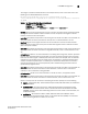
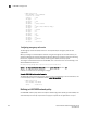
To configure a coordinate-based location for an Endpoint device, enter a command such as the
following at the Global CONFIG level of the CLI.
Brocade(config)#lldp med location-id coordinate-based latitude
-78.303 resolution 20 longitude 34.27 resolution 18 altitude meters 50 resolution
16 wgs84
Syntax: [no] lldp med location-id coordinate-based
latitude degrees resolution bits
longitude degrees resolution bits
altitude floors number resolution bits | meters number resolution bits
datum
latitude degrees is the angular distance north or south from the earth equator measured through
90 degrees. Positive numbers indicate a location north of the equator and negative numbers
indicate a location south of the equator.
resolution bits specifies the precision of the value given for latitude. A smaller value increases the
area within which the device is located. For latitude, enter a number between 1 and 34.
longitude degrees is the angular distance from the intersection of the zero meridian. Positive
values indicate a location east of the prime meridian and negative numbers indicate a location
west of the prime meridian.
resolution bits specifies the precision of the value given for longitude. A smaller value increases the
area within which the device is located. For longitude resolution, enter a number between 1 and
34.
altitude floors number is the vertical elevation of a building above the ground, where 0 represents
the floor level associated with the ground level at the main entrance and larger values represent
floors that are above (higher in altitude) floors with lower values. For example, 2 for the 2nd floor.
Sub-floors can be represented by non-integer values. For example, a mezzanine between floor 1
and floor 2 could be represented as 1.1. Similarly, the mezzanines between floor 4 and floor 5
could be represented as 4.1 and 4.2 respectively. Floors located below ground level could be
represented by negative values.
resolution bits specifies the precision of the value given for altitude. A smaller value increases the
area within which the device is located. For floors resolution, enter the value 0 if the floor is
unknown, or 30 if a valid floor is being specified.
altitude meters number is the vertical elevation in number of meters, as opposed to floors.
resolution bits specifies the precision of the value given for altitude. A smaller value increases the
area within which the device is located. For meters resolution, enter a value from 0 to 30.
Datum is the map used as the basis for calculating the location. Specify one of the following:
• wgs84 – (geographical 3D) – World Geodesic System 1984, CRS Code 4327, Prime Meridian
Name: Greenwich
• nad83-navd88 – North American Datum 1983, CRS Code 4269, Prime Meridian Name:
Greenwich; The associated vertical datum is the North American Vertical Datum of 1988
(NAVD88). Use this datum when referencing locations on land. If land is near tidal water, use
nad83-mllw (below).
• nad83-mllw – North American Datum 1983, CRS Code 4269, Prime Meridian Name:
Greenwich; The associated vertical datum is mean lower low water (MLLW). Use this datum
when referencing locations on water, sea, or ocean.