
User Manual Part 3

Locations Tab
SpectraGuard® Enterprise User Guide
124
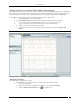
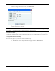
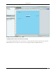
Change RF Property: Select RF Property to change the RF properties of the device. In AP RF
Properties dialog, select the Interface name from the Interface drop-down list. Enter Transmit
Power (mW) and Transmission Calibration Factor (dB). Click Apply and then OK.
AP RF Properties dialog
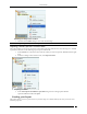
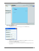
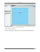
In the Sensor RF Properties dialog select the Interface name from the Interface drop-down list. Enter
Reception Calibration Factor (dB). Click Apply and then OK.
Sensor RF Properties dialog
Setting Coordinates and Deleting Devices from a Floor map
The system enables you to set the coordinates of APs and Sensors placed on the floor map for precise positioning.
You can delete APs and Sensors from your floor map so that the deleted devices can be placed again on the floor map.
Such devices become available under Available Devices. Use the following steps to set the coordinates of a device or
delete a device.
1. Right-click an AP/Sensor placed on the floor map. Do one of the following from the resulting menu:
Select Set Coordinates to open a dialog where you can specify the X and Y coordinates of the
selected device. To set the coordinates, click OK.
Select Delete to remove the AP/Sensor from the floor map.
Resetting your Canvas
The system enables you to reset a canvas to revert to a blank canvas. This option removes all folders and location
information from a location folder. It removes all device and location information, including the background image
and/or any imported Planner file from a location node. All placed devices go back to the Available Devices list. The
system retains the original size and the location name in the sub-list of locations.
Use the following steps to reset a canvas:
1. In the Location tree, select the location at which you wish to reset the canvas and then right-click.
2. From the resulting context-sensitive menu, select Reset Canvas.
3. Click Yes on the Confirm dialog to reset the canvas.
Editing Floor Properties
The system enables you to edit the properties of an existing floor map to change its name and dimensions. Use the
following steps to edit the floor properties:
1. In the Location tree, select the location node whose properties you wish to edit and then right-click.