
User's Manual
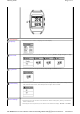

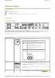


GPS Main Display
Icon Illustration
Current time
Number of satellites detected
Battery power indication
Bluetooth (solid: connected; gray: connecting or scanning; invisible: turned off)
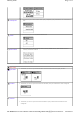
Function Page
Self-defined function page
To create your own page, you may use the following available data fields:
Speed, Distance, Elapsed, Avg. Speed, Max. Speed, Pace, Pedometer, Altitude, Grade, Ascent (Total Ascent), Descent
(Total Descent), GPS, POI, Calories, Heart Rate, Avg. HR, HR %Max, Avg. %Max, and HR Zone.
Note: Grade is only available in "Pro" models.
General function page
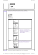
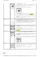
Compass
This main display shows directional information.
The compass function here can be either GPS Compass or Digital
Compass, depending upon different models.
GPS
Compass
The direction shown here is simulated by GPS
for reference. Without GPS fixes, GPS Compass
will become unavailable.
The direction detected will be more precise
when the GPS device is on the move, but
jiggling around when it's moving in low speed
or stays motionless.
Digital
Compass
This is only available with the "Pro" models. With
Digital Compass, you'll be prompted to calibrate the
compass by waving the device twice in a figure 8.
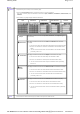
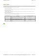
Satellite
The upper half of the display includes information like Satellite ID (numbers)
and corresponding signal strength (bar chart).
The lower half of the display includes information like GPS precision and
coordinates of current position.
Note: The solid bar indicates a valid satellite detected, while the hollow bar indicates an invalid
satellite detected.
Location Navi
This main display includes POI information uploaded from Route Planner, such
as current distance (e.g. 16.83 km), estimated time of arrival (e.g. 20:49),
Page
1
of
3
GT800_display
2012/10/13
mk:@MSITStore:C:\Documents%20and%20Settings\Paul1106\
桌面
\
Travel%20&%2
...