
User manual


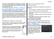


Table Of Contents
- Nokia E75 User Guide
- Contents
- Safety
- Quick start guide
- Nokia E75 - The basics
- Personalization
- New from Nokia Eseries
- Messaging
- Phone
- Internet
- Traveling
- Positioning (GPS)
- Maps
- Maps
- Network positioning
- Move on a map
- Display indicators
- Find locations
- Plan a route
- Save and send locations
- View your saved items
- Navigate to the destination
- Walk to your destination
- Drive to your destination
- Traffic information
- Travel guides
- Maps settings
- Internet settings
- Navigation settings
- Route settings
- Map settings
- Update maps
- Nokia Map Loader
- Shortcuts
- Nokia Office Tools
- Media
- Connectivity
- Security and data management
- Settings
- General settings
- Telephone settings
- Connection settings
- Access points
- Packet data (GPRS) settings
- WLAN settings
- Advanced WLAN settings
- WLAN security settings
- WEP security settings
- WEP key settings
- 802.1x security settings
- WPA security settings
- Wireless LAN plugins
- Session initiation protocol (SIP) settings
- Edit SIP profiles
- Edit SIP proxy servers
- Edit registration servers
- Configuration settings
- Restrict packet data
- Application settings
- Shortcuts
- Glossary
- Troubleshooting
- Battery
- Care and maintenance
- Additional safety information
- Index

Initially, your device must receive signals from at least four
satellites to be able to calculate the coordinates of your
location. When the initial calculation has been made, it may
be possible to continue calculating the coordinates of your
location with three satellites. However, the accuracy is
generally better when more satellites are found.
Position requests
You may receive a request from a network service to receive
your position information. Service providers may offer
information about local topics, such as weather or traffic
conditions, based on the location of your device.
When you receive a position request, the service that is
making the request is displayed. Select Accept to allow your
position information to be sent or Reject to deny the request.
Landmarks
Select Menu > Applications > GPS > Landmarks.
With Landmarks, you can save the position information of
specific locations in your device. You can sort the saved
locations into different categories, such as business, and add
other information to them, such as addresses. You can use
your saved landmarks in compatible applications, such as GPS
data.
GPS coordinates are expressed in the degrees and decimal
degrees format using the international WGS-84 coordinate
system.
Select Options and from the following:
• New landmark — Create a new landmark. To make a
positioning request for your current location, select
Current position. To select the location from map, select
Select from map. To enter the position information
manually, select Enter manually.
• Edit — Edit or add information to a saved landmark (for
example, a street address).
• Add to category — Add a landmark to a category in
Landmarks. Select each category to which you want to add
the landmark.
• Send — Send one or several landmarks to a compatible
device. Your received landmarks are placed in the Inbox
folder in Messaging.
You can sort your landmarks into preset categories, and
create new categories. To edit and create new landmark
categories, open the categories tab, and select Options >
Edit categories.
GPS data
Select Menu > Applications > GPS > GPS data.
GPS data is designed to provide route guidance information
to a selected destination, position information about your
current location, and traveling information, such as the
approximate distance to the destination and the
approximate duration of travel.
The coordinates in the GPS are expressed in degrees and
decimal degrees format using the international WGS-84
coordinate system.
Traveling
© 2008 Nokia. All rights reserved.84