
User manual
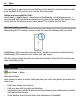
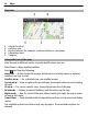
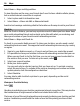
Table Of Contents
- Nokia C5–04 User Guide
- Contents
- Safety
- Find help
- Get started
- Your device
- Make calls
- Write text
- Contacts
- Messaging
- Music player
- Camera
- Gallery
- Share online
- Nokia Video Center
- Web browser
- Positioning (GPS)
- Maps
- Maps overview
- View your location and the map
- Map view
- Change the look of the map
- Download and update maps
- About positioning methods
- Find a location
- View location details
- Save or view a place or route
- Send a place to a friend
- Check in
- Synchronize your Favorites
- Get voice guidance
- Drive to your destination
- Navigation view
- Get traffic and safety information
- Walk to your destination
- Plan a route
- Connectivity
- Protect the environment
- Product and safety information
- Copyright and other notices

Map view
1 Selected location
2 Indicator area
3 Point of interest (for example, a railroad station or a museum)
4 Information area
5 Compass
Change the look of the map
View the map in different modes, to easily identify where you are.
Select Menu > Maps and My position.
Select
and from the following:
Map view — In the standard map view, details such as location names or highway
numbers, are easy to read.
Satellite view — For a detailed view, use satellite images.
Terrain view — View at a glance the ground type, for example, when you are traveling
off-road.
3D view — For a more realistic view, change the perspective of the map.
Landmarks — Display prominent buildings and attractions on the map.
Night mode — Dim the colors of the map. When traveling at night, the map is easier
to read in this mode.
Transit lines — View selected public transportation services, such as metro and trolley
routes.
The available options and features may vary by region. The unavailable options are
dimmed.
46 Maps