
Software Manual


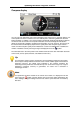
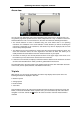

Table Of Contents
- Chapter 1. Introduction
- Chapter 2. Manual installation and start-up
- Chapter 3. Installation and start-up using the GoPal® Assistant
- Chapter 4. Basics of operation
- Chapter 5. Adjusting the Settings
- Chapter 6. Operating the GoPal® navigation software
Operating the GoPal
®
navigation software
49
• The map section is shown on the whole screen: if necessary, in the Settings > Display > Map
view menu, you can activate the Dynamic (depending on the manoeuvre, the arrow view is
activated) or Arrow and Map (split-screen) options: split-screen shows a combination of arrow
and map view and also allows access to the first two buttons in the Quick menu.
• Within the map section, the planned route is shown in blue.
• The street on which you are currently located is shown on the upper edge of the screen. The
distance to the next manœuvre is also shown.
• Your current position is displayed on the map using the symbol.
• Information regarding the current and average speed, the distance to the destination, remaining
travel and arrival time (only in the 480 x 272 pixel, portrait display format) is shown on the
information bar on the lower edge of the map display (see also Operation in map view).
• The current map section is automatically zoomed prior to a manœuvre and after the manœuvre
the section returns to its previous size. You can adjust the desired zoom in the menu Display >
Auto zoom in Settings (see Adjusting the display). You can adjust the zoom of the map section
manually using the and buttons as needed. The current scale is displayed on the map.
• The map view is switched prior to a manoeuvre: The planned direction, distance to the
manœuvre and the arrow view are displayed on the upper edge of the screen. The normal map
display is activated again after the manoeuvre.
• POIs such as petrol stations, rest areas etc. are displayed as symbols in the map display.
Tip
You can manually move the current map section within the screen if needed, in order to,
for example, show the POIs in the area of the calculated route in the map view. To do so,
tap a suitable position in the map section, hold the position and move it around the
screen as desired: The map section is adjusted accordingly.
In addition to the visual navigation, all manœuvres are also announced using voice commands.
You can adjust the voice output during navigation as follows:
• Tap the button in the upper left area of the screen: The setting menu Volume then opens,
which allows you to individually set the volume for voice output, the key click and audio playback
of MP3 files using the additional MP3 Player application. The volume set at this point also
applies to the output over the internal speakers as well as via the earphone connection (3.5 mm
mini plug) on your navigation device.
o The buttons and allow you to individually lower or raise the volume for the respective
signal output in six steps. Output for the respective signal is muted at the lowest level.
Note
The volume setting is saved and the stored value will be used the next time you start-up
your navigation system.