
Operation Manual

25
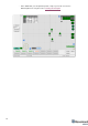
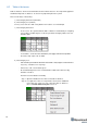
6.2 Table of distances
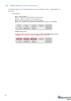
Table of distances shows measured distance between all the beacons. The map and its graphical
visualization depends on distances. So, that is very important part of the system.
There are two ways of measuring:
1) Measuring by ultrasound (automatic)
2) Measuring by user (manual)
*In noisy cases and cases with a long distance it is better to use manual input
1) Measuring by ultrasound:
- In most cases, the system builds the table of distances automatically. If everything
is good, there would be figures in cells, they would be changing a little; cells color
would be white
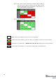
- If color differs, check the colors’ definitions (next page) and solve the problem
- Freeze the map only if cells are white
2) Measuring by user:
- Use manual input if table of distances didn’t build. It may happen if environment is
very noisy, or distances are very huge
- In that case, cells’ color would be green
- Be careful with figures because a small mistake in that values will cause big
mistakes in location
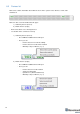
How to freeze/enter distance manually:
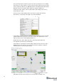
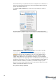
Step 1. Open the Dashboard. You will see the table of distances
Step 2. Use right mouse click on cell you want to freeze/enter. Additional
menu will open. There you can control the table of distances.
Choose Freeze distance for pair to freeze it