
Specifications


78
If you are in luck, the area is relatively flat and there is a
straight road running from the existing control point to the two
new points to be established, thus minimizing the number of
legs required to complete the loop.
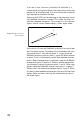
Surveying with GPS has the advantage of not requiring line-of-
sight between the points surveyed. This allows for direct ob-
servations between the points. To illustrate this, let’s take our
3-point control survey network design, shown again below.
Assume that a 2-receiver ProMark3 system will be used to per-
form the above survey. To produce the link between the exist-
ing control point 1 and the new point 2, simply place one
ProMark3 receiver system on point 1, place the other receiver
on point 2 and simultaneously collect data between the two
points. When the observation is complete, move the ProMark3
receiver from point 2 to point 3. Perform another observation,
simultaneously collecting data on points 1 and 3. When com
-
pleted, move the ProMark3 receiver from point 1 to point 2.
Perform the final observation between points 3 and 2. When
this data is downloaded and processed, the result will be three
vectors (delta positions) forming the network design seen in
the above figure.
1
2
3
Network Design for 3-Point
Control Survey