
Specifications


19
Additional GPS receivers are used to locate linear objects
such as roads or collect data in a linear fashion for developing
topographic elevation data.
The recording interval should be set to collect the amount of
data needed relative to the speed of travel.
A recording interval too long will result in insufficient data.
After data collection is complete, data is downloaded from the
GPS receivers to an office computer for post-processing using
the GNSS Solutions software. The post-processing activity
computes positions of all observed points relative to one or
more fixed point positions. The Kinematic data collection
method is best used for delineating linear type features such
as roads, fences, lakes, etc.
Real-Time Surveying with ProMark3 RTK
The ProMark3 RTK system has all the survey and mobile map-
ping functions of a ProMark3, but in addition, it can perform
real-time surveys. In this operating mode, the ProMark3 RTK
delivers real-time, centimeter-accurate position solutions.
The ProMark3 RTK allows you to also log raw data while a real-
time survey is in progress.
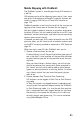
As shown in the diagram below, there are two possible system
configurations to implement RTK in the ProMark3 RTK:
- In base/rover configuration, you need to install your own
base as well as a radio link to transfer RTCM corrections
from the base to the rover.
- In rover-only configuration, you need a Bluetooth-enabled,
GPRS-enabled cell phone to connect the ProMark3 RTK to
the Internet. RTCM corrections will be delivered to the
unit by an external corrections provider, via the Internet
and the cell phone.
Base/Rover Rover-Only
(Network Connection)
Base
Rover
Radio Data Link
Rover
GPRS Data Link
Internet
+ Cell
Phone