
User's Manual

33
5. Turn around 180 degrees and start the next track
backwards for example 1m next to the rst one
pressing
ZERO to start. Avoid overlaps of the tracks
when searching track by track.
6. Stop the last track with
ZERO and store the same
as a new eld while pressing
OFF/ FIELD shortly
afterwards.
7. Leave the DEEPMAX Z2 on and connect the USB
data transfer cable to the DEEPMAX Z2 and read the
data with your computer and installed Surfer and
Lorenz Scripter Software, as described in the instruc-
tions free for download on our website at Service.
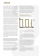
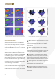
8. Compare the six dierent colour maps generated
with Surfer to distinguish between dierent kinds
of metals, objects sizes, orientation and ground
minerals.
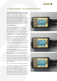
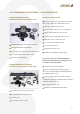
In addition, there are dierent indication icons on
the display to make the operation of the data log-
ger even simpler as follows:
M Meter displays the meters already passed in
the rst track and counts backwards in the follo-
wing tracks to zero in order to nd the starting and
nishing line X of each track.
TR Track indicates the currently active track and
the amount of tracks already being stored.
FI Field indicates the eld currently in use and
jumps to a higher number when storing the last
track with the FIELD button shortly.
HDG Heading information of the compass
function to display the direction of the tracks in Y
direction. While being in the process of recording
eld data it is possible to press MENU in order to
choose between Meter, Track, Field and Heading
information on the display
+/-180° comes on when walking backwards a
track in order to show that this amount of degrees
has to be added or deducted from the displayed
Heading to obtain the compass heading.
GPS has to come on when a Battery + GPS mo-
dule is connected the GPS is turned on and DLOG 1
or 2 is selected and starts to ash when no accurate
GPS data can be received or during the warming
up phase. The Z2 will work without GPS as well but
does not provide the compass heading and meter
function in this case.
DATA LOGGER operation icon comes on when
DLOG is on.
BARGRAPH dot for compass heading informa-
tion shows the operator how to go in straight line
each track. For example, the operator has to go
to the left when the dot goes to the left or to the
right when the dot drifts to the right. This has to be
performed as long until the dot comes back to the
middle. The operator will notice some delay until this
indication reacts. It is absolutely necessary that the
operator walks to make a valid GPS indication possi-
ble. Therefore at least ten meters should be passed
until the indicated GPS data is tolerable accurate.
USB icon comes on when USB data transfer
cable is connected with the computer and data
transfer is in process.
All mentioned functions, settings, specications
and indication examples subject to change without
notice.