
Manual


LW20 / SF20 LiDAR sensor
Product manual
1. Overview of the LW20
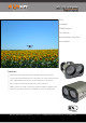
The LW20 LiDAR is a compact laser rangefinder for use on drones, self-driving vehicles and robots. It
is designed to connect to many different processors using a serial or I2C protocol and runs from a
single 5 V power source.
The LW20 LiDAR offers professional grade performance in a tiny form factor. It can be used as a
distance measuring sensor or attached to a servo to create LiDAR maps that sense the world as two
dimensional images.
Measurements can be made to target surfaces up to 100 meters away in sunlit conditions. In
scanning mode up to 388 measurements can be made each second. The data can be streamed from
the communication ports or analysed internally to look for potentially hazardous alarm conditions.
The LW20 is also available as an open frame module for OEMs using part code SF20.
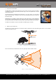
2. What can the LW20 do?
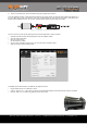
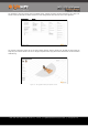
The LW20 can be used as an altimeter on multi-copter drones to measure the exact height above ground level or to set off alarms
when the ground gets too close.
Figure 1 :: Measuring exact height above ground
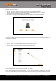
With a servo attached, the LW20 becomes a low cost, lightweight collision avoidance sensor.
Figure 2 :: Collision avoidance zones
LW20 / SF20 LiDAR - Product manual - Revision 9 | of | © LightWare Optoelectronics (Pty) Ltd, 2018 | www.lightware.co.za 4 28