
Owner's manual


LandMark Mobile User’s Manual 51
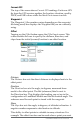
Current GPS
The top of the screen shows Current GPS readings. Each new GPS
x from the GPS receiver updates the location, elevation, quality,
PDOP, and EHE values while the Mark Point screen is active.
Waypoint #
The Waypoint 1 (the number varies depending on the waypoint
le being used) box displays the Waypoint le you are currently
using.
Offset
Tapping on the Oset buon opens the Oset Input screen. This
screen enables the user to specify the distance, direction, and
slope from the initial (current) location to an oset location.
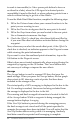
Distance
The Distance box sets the direct distance in displayed units to the
oset point.
Direction
The Direction box sets the angle, in degrees, measured from
north to the oset point. The Ref (reference) label is next to
the Direction box. This displays the heading you set up in the
conguration of LandMark Mobile and the declination angle. The
reference used for each point is stored with the waypoint.
Slope
The Slope box sets the angle, in degrees, of altitude inclination. A
negative number represents a declination in altitude.
This ability to oset points is valuable in many situations. For
example: The oset function can be used when a point you want