
Owner's manual
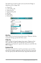

42 LandMark Mobile User’s Manual
The World Magnetic Model Epoch 2000 (WMM-2000 or WMM
2K) is a generated model used to congure and display magnetic
north in GPS units. The World Magnetic Model coecients are
produced and distributed by the National Geospatial Intelligence
Agency (formerly National Imagery Mapping Agency),
Washington, D.C.
The model, associated soware, and documentation are
distributed by NGDC on behalf of NGA. The model is produced
at 5-year intervals. The 2010–2015 model will be available from
NGDC on the following website in December 2009:
hp://www.ngdc.noaa.gov/geomag/WMM/DoDWMM.shtml
Follow the directions on the above website to download the
necessary le. Once the le is downloaded, place the le in the
LandMark Mobile folder on your Field PC.
Note: Some GPS receivers may not supply the magnetic declination. If
your GPS receiver uses the Sirf chipset, it probably does not provide the
magnetic declination value.
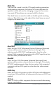
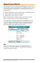
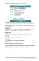
Format
The Format option allows you to select the format for displaying
your location. Latitude and longitude can be set to degrees,
degrees and minutes, or degrees, minutes, and seconds; UTM can
be set to a northing/easting format.
Format What is Displayed
ddd.ddddddd latitude/longitude in decimal degrees
ddd mm.mmmm latitude/longitude in degrees and decimal
minutes
ddd mm mss.ss latitude/longitude in degrees, minutes and
seconds
UTM northings/eastings
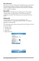
Altitude Reference
The Altitude Reference option displays the altitude as MSL (mean
sea level) or HAE (height above ellipsoid). When MSL is selected,
its value is calculated when the GPS receiver provides the geoidal
separation value in the NMEA GGA packets from the satellite.