
Owner's manual

40 LandMark Mobile User’s Manual
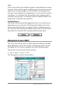
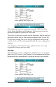
Units Tab
The Units tab is used to format data. For example, say that your
data needs to be calculated in feet, with magnetic declination set,
in UTM scale, and mean sea level altitude reference set. Set up all
of these congurations in the Units tab. Selected seings are also
used in displayed data for Keyboard Wedge and Memory Exchange.
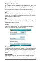
Datum
The Datum option is a set of constants used for calculating
coordinates on earth. A datum is used by the GPS to reference a
coordinate on the earth’s surface. LandMark Mobile automatically
defaults to WGS-84, the datum constants established by the
World Geodetic System in 1984 (WGS 84).
A selection of over 200 dierent map datum points from around
the world can be used to convert the position to a dierent
datum. When waypoints are stored, they are always recorded in
the WGS 84 datum.
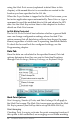
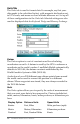
Units
The Units option allows you to specify the units of measurement
that you want your data to be expressed in. Choices include feet,
miles, meters, kilometers, knots, miles per hour, or kilometers per
hour.
Display Option Distance Units Speed Units
Statute Feet, Miles Miles per hour (mph)
Metric Meters, Kilometers Kilometers per hour
Nautical Feet, Nautical Miles Knots