
Instruction Manual


76 LandMark CE User’s Manual
Mark GPS — Pushed
This function opens the LandMark CE mark waypoint screen so that
a user can mark a waypoint and then return with the new data. It has
the same arguments as the pulled version of Mark GPS.
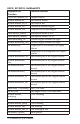
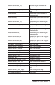
LMCE_API BOOL GetMarkBLK
Argument for Function Function Affected
(DWORD &mark_tic, Unique Data ID
double &mark_alt, Elevation in meters
double&mark_alt_ft, Elevation in feet
double &mark_lat, Latitude in decimal degree
double &mark_lon, Longitude in decimal degree
char &mark_lathem, Hemisphere in N or S
char &mark_lonhem, Hemisphere in E or W
double &markdeg_lat, Decimal degree without the
signs
double &markdeg_lon, Decimal degree without the
signs
int &markilat, Integer part of the latitude for
Degree minute
int &markilon, Integer part of the longitude for
Degree minute
double &markmin_lat, The minute part of the Degree
Minute
double &markmin_lon, The minute part of the Degree
Minute
int &markiminlat, The minute part of the Degree
Minute Second
int &markiminlon, The minute part of the Degree
Minute Second
double &marksec_lat, The second mart of the Degree
Minute Second
double &marksec_lon, The second part of the Degree
Minute Second
char mark_UTMZone[] The UTM Zone
double &mark_northing, The UTM northing
double &mark_easting, The UTM easting
▲