
Instruction Manual


LandMark CE User’s Manual 73
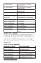
short &mask_msg; If GPS was fi ltered, this indicates the
reason
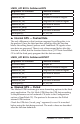
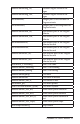
Mask Flags
0 GPS data not masked.
1 GPS not in 3D mode.
2 PDOP is greater than maximum allowed
3 GPS not in DGPS mode.
4 Satellite SNR is below the minimum allowed
5 Satellite elevation is below the minimum allowed
6 EHE is greater than the maximum allowed
7 No fi x
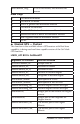
Masked GPS — Pushed
This function is the available when a GPS receiver with Real time
capability is being used real-time capable version of the Get Mask
GPS function.
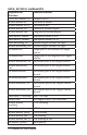
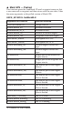
LMCE_API BOOL GetMaskRT
Argument for Function Function Affected
(DWORD &mask_tic Unique Data ID
double &mask_alt, Elevation in meters
double &mask_alt_ft, Elevation in feet
double &mask_lat, Latitude in decimal degree
double &mask_lon, Longitude in decimal degree
char &mask_lathem Hemisphere in N or S
char &mask_lonhem, Hemisphere in East or West
double &maskdeg_lat, Decimal degree without the signs
double &maskdeg_lon, Decimal degree without the signs
int&maskilat, Integer part of the latitude for Degree
minute
int &maskilon, Integer part of the longitude for
Degree minute
double &maskmin_lat, The minute part of the Degree
Minute
double &maskmin_lon, The minute part of the Degree
Minute
▲