
Operation Manual


● ● ● ● ● ● ● ● ● ● ● ● ● ● ● ● ● ● ● ● ● ● ● ● ● ● ● ● ● ● ● ● ● ● ● ● ● ● ●
3-77
3
Note: Navigation information can have a maximum of 256 points
plotted. Note that the value of REMAIN POINTS (the number
of points that can be still plotted) is decreased whenever
lines and marks are plotted.
3 CORRECT (Correct one position of navigational information)
1 Click CORRECT .
CORRECT will be selected. CORRECT will
appear in the CURSOR( ) at the upper right of
the radar display.
2 Move the cross cursor mark to any
line element or mark to correct using
the trackball, and click the trackball
section left button.
A dotted-line starting from the line or mark will be
drawn as the cross cursor moves.
3 Move the cross cursor to the point to
correct using the trackball, and click
the trackball section left button.
One element of the line or the mark will be
moved.
4 DELETE (Delete one point in navigational
information)
1 Click DELETE .
DELETE will be selected. NAV DEL will appear
in the CURSOR( ) at the upper right of the radar
display.
2 Move the cross cursor mark to any
line element or mark to delete using
the trackball, and click the trackball
section left button.
One element of the line or the mark will be
deleted.
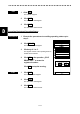
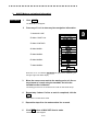
Procedures
Procedures
SUB1 MENU
1.
0.
EXIT
NAV/MAP INFO
NAV/MAP
EDIT
2.
3.
CLEAR
MAKE
4.
5.
CORRECT
DELETE
INSERT
REMAIN POINT
256
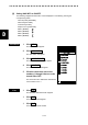
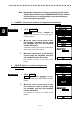
SUB1 MENU
1.
0.
EXIT
NAV/MAP INFO
NAV/MAP
EDIT
2.
3.
CLEAR
MAKE
4.
5.
CORRECT
DELETE
INSERT
REMAIN POINT
256