
User's Manual


14
www.jotron.com www.jotron.com
85525_UM_60S/GPS_ J
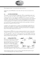
1.2.2 DISTRESS LOCATION DETERMINATION
The location of the distress signal is determined by taking
measurements of the doppler shift of the EPIRB frequency
when the satellite first approach and then pass the EPIRB.
The actual frequency is heard at the time of closest approach
(TCA). Knowing the position of the satellite and using the re-
ceived doppler signal information, it is possible to determine
the location of the Tron 60S/GPS from the satellite at the
TCA. At the LUT, actually two positions are calculated. One is
the actual position (A) and the other is the mirror image (B)
position. A second satellite pass confirms the correct location (A). Doppler-
only accuracy is within 5 km (3 mi) (3.1 statute miles or 2.6 nautical miles)— that
is, the position is sufficiently accurate for SAR purposes even after only one
pass. What’s more, the most likely of the two ’mirror’ positions can be deter-
mined valid with 98.5% accuracy after only one satellite pass. This accuracy can
be increased to 99.3% using so-called ”combined Leo-Geo processing,” and
this technique also enables accurate positions to be generated with as little as
two or three bursts from the beacon (i.e. less than 4 minutes of transmission)
and thus greatly increases the chances of being found even if the beacon is
ultimately consumed by fire or is otherwise destroyed
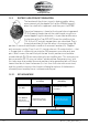
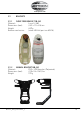
1.2.2.1 GPS ADVANTAGE
Polar orbiting satellites
(LEOSAR)
Geostationary satellites
(GEOSAR)
Tron 60S
Delayed alert (<90 min)
Position by Doppler (5km)
Immediate alert (<5 min)
NO position
Tron 60GPS
(MMSI Standard
Location Protocol Long)
Delayed alert (<90 min)
Position by GPS (120m)
Immediate alert (<5 min)
Position by GPS (120m)
Longer delay,
Low resolution position
Fast alert and accurate
position