
User's Manual
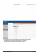
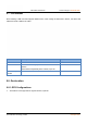
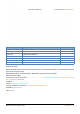

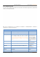
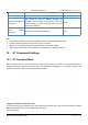
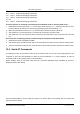
Table Of Contents
- USR-G809 User Manual
- 1.Introduction
- 1.1.Overview
- 1.2.Features
- 1.3.Specification
- 1.4.Interface
- 1.5.Indicator
- 1.6.Dimensions
- 2.General Function
- 2.1.Web Interface
- 2.2.Hostname
- 2.3.User Password Settings
- 2.4.Reboot Timer
- 2.6.Reboot
- 2.7.Reload Button
- 3.Interface
- 3.1.WAN Interface
- 3.2.LAN Interface
- 3.3.Cellular Network Interface
- 3.4.WLAN Interface
- 3.5.VLAN
- 3.6.DIDO
- 4.Network
- 4.1.Network Switch
- 4.2.DHCP
- 4.3.Hostnames
- 4.4.Static Routes
- 4.5.Diagnostics
- 5.VPN
- 5.1.PPTP Client
- 5.2.L2TP Client
- 5.3.IPSec
- 5.4.OpenVPN
- 5.5.GRE
- 6.Firewall
- 6.1.General Settings
- 6.2.NAT
- 6.3.Traffic Rules
- 6.4.Access Restriction
- 7.Serial Port
- 7.1.Connecting Hardware
- 7.2.Serial Port Settings
- 7.3.Operation Mode
- 7.4.General Function
- Protocol description:
- 8.USR Cloud
- 8.1.Cloud Monitor
- 8.2.Add device
- 8.3.Network Status
- 8.4.Parameter Configuration
- 8.5.Firmware Upgrade
- 8.6.Records of device
- 8.7.Alarm
- 8.8.Remote Configuration
- 9.Services
- 9.1.Syslog
- 9.2.NTP
- 9.3.Email
- 9.4.SMS
- 9.5.Alert
- 9.6.Alert Examples
- 9.7.Call Reboot
- 9.8.Geolocation
- 9.9.DDNS
- 10.AT Commands Settings

USR-G809 User Manual Technical Support:
h.usriot.com
Jinan USR IOT Technology Limited www.pusr.com
93
Item
Description
Default
GPS
Enable/Disable
Disable
Socket selection
SocketA or Custom
SocketA
Device ID
Modbus RTU device ID
1
Register address
Modbus RTU register address
0
Interval (s)
Uploading interval, 1-6000s
60
Server custom address
Custom GPS server address, IP or domain Item.
clouddata.usr.cn
Server port
Custom GPS server port
15000
GPS frame format:
(When the GPS sensor is abnormal and cannot locate the coordinate information, the latitude and longitude
in the frame are (0.00, 0.00)).
USR-G809 will report the location data in Modbus RTU to the GPS server actively.
Data reported by G809:
01 46 00 00 00 12 24 00 06 00 01 68 90 E7 27 48 C9 40 5D C4 FD 85 AA 56 7E 40 42 01 CC 00 00 00 64 00
00 F2 59 5C 87 13 56 2D 2E
Longitude: 68 90 E7 27 48 C9 40 5D
Latitude: C4 FD 85 AA 56 7E 40 42
10 bytes base station positioning: 01 CC 00 00 00 64 00 00 F2 59
Timestamp: 5C 87 13 56
CRC: 2D 2E