
Operation Manual


58 User Manual
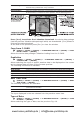
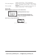
Graphical representation on Map Display
Fig. 5.2 - Graphical Displaying
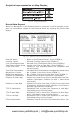
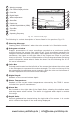
Route Data Report
When the Navigation to the External Route is received, it will be possible to dis-
play the information related to the External Route by entering the Route Data
Report.
Fig. 5.2a - External route on Route Data Report
External Route : Name of the External Route (from PCMPN,0)
Cruising Speed : Planned Cruising Speed (from PCMPN,1)
Fuel Consumption Rate : Planned Fuel Consumption Rate (from PCMPN,1)
Total Route length Route: Length from First to Last Wpt. (from PCMPN,1)
Initial Fuel Load : Volume of Fuel available before the navigation was
started (Liters)
Total Fuel Consumption : Calculated Fuel consumption to navigate the whole route.
Waypoints in Route : No. of Wpts in the Route (from PCMPN,1)
Remaining Waypoints : No. of Wpts from Dest to Last Wpt (from PCMPN,1)
Distance to Destination : Distance from Ship to Destination (Calculated)
Distance to Next Wpt : Distance to travel from ship to the Wpt after the Des-
tination (calculated: Distance to Dest + Next Route
Leg length)
Distance to Last Wpt : Distance to travel from ship to the End of the Route
(Calculated: Distance to Dest +Distance From Dest to
last Wpt received from PCMPN,1)
TTG To Destination : Estimated Time to travel the “Distance to Last Wpt”.
Calculated using Cruising Speed.
TTG To Next Wpt : Estimated Time to travel the “Distance to Next Way-
point” Calculated using Cruising Speed.
TTG to Last Wpt : Estimated Time to travel the “Distance to Last Wpt”.
Calculated using Cruising Speed
ETA to Destination : Estimate Time of Arrival to the Destination Point. Cal-
www.busse-yachtshop.de | info@busse-yachtshop.de