
Operation Manual


20 User Manual
2.4 USING C-MAP BY JEPPESEN C-CARDS
The chart plotter has a built-in world map that can be used for Route planning. To
use the chart plotter as a navigation aid, charts with detailed information for the
area you wish to navigate are required. This chart cartridge is called C-CARD.
NOTE During normal operations the C-CARD should not be removed since the chart
plotter may lock up.
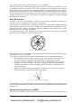
2.5 SIMULATION MODE
The built-in Simulator function allows you to become proficient in the use of the
chart plotter. It simulates the reception of the navigation data (Lat/Lon, Course,
Speed, date, time). The simulated ship's position is placed at the current cursor
position by the time the simulation is activated. To start the Simulator:
Place the cursor at your desired position + [MENU] + "MENU" + [ENTER] +
"SIMULATION" + [ENTER] + "SIMULATION MODE" + [ENTER] + "ON" +
[ENTER]
You might insert the Speed, Course, date and time values:
[MENU] + "MENU" + [ENTER] + "SIMULATION" + [ENTER] + "COURSE"/
"SPEED"/"DATE"/"TIME" + [ENTER] + enter values + [ENTER]
To select the Cursor Control in Chart page use the cursor up/down to adjust the
Speed and the cursor left/right to adjust the Course:
[MENU] + "MENU" + [ENTER] + "SIMULATION" + [ENTER] + "CURSOR
CONTROL" + [ENTER] + "ON" + [ENTER]
2.6 CONTROLLING THE DISPLAY
This paragraph describes how to change the display mode and how to move
around the chart by changing the chart scale.
Changing Display Mode
[PAGE] + move the cursor up/down + [ENTER]
The selected page appears on the screen.
NOTE If the Fish Finder or Radar is connected, other displaying pages are available
too.
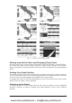
NOTE See the following table for help to understand the GPS Signal Status page:
COLOR STATUS SNR ELEVATION
GREEN Tracked - In Use > 40 <= 45°
GREEN Tracked - In Use > 40 > 45°
GREEN Tracked - In Use < 40 <= 45°
ORANGE Tracked - In Use <= 40 > 45°
RED Tracked - Not In Use - - - -
GRAY Not Tracked - - - -
www.busse-yachtshop.de | info@busse-yachtshop.de