
Operation Manual


15
User Manual
1. Overview
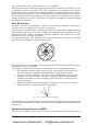
1.1 CHART PLOTTER
Cursor Key : in the display screen moves the cursor quickly and accurately
in the menu page(s) scrolls the desired option
in Home mode, allows to exit from Home mode
POWER : turns On/Off the chart plotter
adjusts the backlight and contrast of the display
MOB : activates the MOB (Man OverBoard)
PAGE : selects the screen configuration you wish
CLEAR : if you are into a menu, exits from menu or leaves a menu without making changes
ENTER : if you are in chart page, places Marks, Waypoints and selects Range/Bearing
if you are into a menu, confirms selection
HOME : sets Home (Navigate) mode: the cursor is centered on ship's position
GOTO : places the Destination (Target or Goto) and activates the navigation to it
MENU : opens the menu on the top of the page
ZOOM IN : increases the chart scale and zooms in on your display
ZOOM OUT : decreases the scale and shows a wider view
Software Keys : have different functions according to the modes of operation: their labels for the
current functions, located on the front panel, are shown on the screen right above the
keys.
1.2 C-MAP BY JEPPESEN MAX CARTOGRAPHY INFORMATION
MAX is a major evolution of the product technology. Key points are:
Data Features
♦ ISO Certification (electronic chart production process with quality
certification)
♦ Extra Large Coverage (all the C-MAP BY JEPPESEN electronic chart de-
tail and a huge coverage without having to change cartridge)
♦ Official data source (data based on use of official data sources)
♦ Detailed World Background (worldwide background chart with details)
♦ Depths & Land Elevation (color shading of sea depth and land alti-
tude for improved chart reading)
♦ Bathymetric & Spot Soundings (additional Data Base with depth
and bathy information for an extraordinary view of the seabed depth)
♦ Detailed Port Plan (complete port and marina charts with detail)
♦ Search & Find (quickly locates chart contents and objects)
♦ Tides Preview (dynamic simulation of tides)
♦ Dynamic Currents (current arrows dynamically display direction and
speed)
♦ Dynamic Nav-Aids (displays Nav-Aids in true color and with real in-
terval lighting)
♦ Port Info (all the information of the available services in the ports and
how to contact them)
♦ Enhanced Port Info & Roads (details of the available facilities and
services in ports and surrounding areas)
♦ Object Info (indicates restricted area details and related information)
♦ Quick Info (full information on objects, buoys, wrecks, shoals and
Nav-Aids)
www.busse-yachtshop.de | info@busse-yachtshop.de