
User Guide

Intellisense Systems Inc.
Page 1
TM-AWAR-USG rev 1
User Guide – AWARE Flood System
OPERATING THE AWARE FLOOD SYSTEM
The AWARE Flood System was designed with simple commands and an open architecture that will work
with nearly every existing network or platform. This document explains the commands, initialization, and
website navigation at https://flashflood.info so that users can set up their AWARE Flood System and access
their data within minutes.
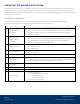
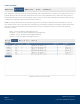
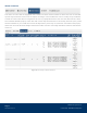
AWARE Flood Commands
The AWARE Flood Node can be remotely configured and commanded via two-way cellular LTE-M
communication. Below is a list of all the commands that the unit can receive:
Command Parameter
Description
1
Depth Detection
Thresholds
Range: 2 – 508 in
Allows the customer to set three independent water level thresholds.
Activation triggers the unit to send immediate notification and data
packet up detection.
2
Set Water Level
Rise/Drop Rate
Thresholds
Range: 0.01-152.5 in/min
Allows the customer to set independent thresholds based on water level
rise and fall rates. Activation triggers the unit to send immediate
notification and data packet up detection.
3 Reporting Mode
Auto reporting mode (Switches to Slow Mode on low Battery)
Fast Mode (10-min)
Slow Mode (1-hr)
4 Sampling Mode
30-second mode
60-second mode
5
Saltwater Adjustment
Applies appropriate calibration factor for saltwater/freshwater
6 Image Request
Request an image on the next scheduled data report
*Future upgrades will allow users to make the AWARE Node prioritize
images and send the image immediately upon request
7 GPS Update
Request a GPS location update on the next scheduled update (0600 or 1800
UTC)
8
Reboot Command
If needed, the customer can reboot the AWARE Flood Node remotely
9
Set Calibration Value
Allows the user to customize the calibration value ±6.35 mb
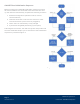
10 Imaging Modes
Triggered Imaging
o Depth Detection Imaging
o Rise Rate Imaging
o Drop Rate Imaging
High-Resolution Imaging