
User Guide

Intellisense Systems Inc.
Page 13
TM-AWAR-USG rev 1
User Guide – AWARE Flood System
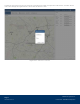
Mean Sea Level (MSL) Setting
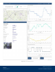
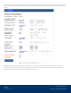
The Mean Sea Level (MSL) setting allows the user to know the exact water height relative to other
structures with a known elevation from sea level. To enable this function, a surveyed WLP sensor elevation
must be entered into the Elevation text box at the bottom of the unit dashboard, (as shown in the image
below). Once the elevation is entered, press the “Set Elevation” button next to the text box.
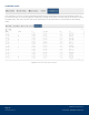
Figure 11: The MSL Elevation Text Box
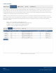
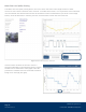
Once the exact elevation of the WLP sensor is
entered, enable MSL in the Depths graph by clicking
the MSL text at the bottom of the graph. Once the
parameter is enabled, the text will be black without
being struck through (see right).