
Quick Start Guide
ManualsBrandsIntelligent Automation ManualsComputers & AccessoriesARGUS Guardian is a fence-mounted, RF-based perimeter intrusion detection system. This system uses a network of unattended wireless sensors to create a wireless trip wire along a perimeter to provide early warnings against intrusions.


Page | 15
© 2018 Intelligent Automation, Inc.
4.5 Node Positioning
The process of Node Positioning involves specifying the locations of each ARGUS GUARDIAN node within
the configuration. There are multiple methods for accomplishing this.
4.5.1 Drag-and-Drop Node Positioning
Any node may be manually positioned at any time (in Configuration Mode) by dragging the node to a
new position on the Map View. The node may be dragged from the Node Manager list on the left side of
the GUI onto the Map View, or from another location on the Map View.
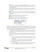
4.5.2 Manual Lat/Long Node Positioning
If a specific latitude/longitude position for a node is known, it can be manually typed into the Node
Configuration Window (see Figure 15). This window is displayed by clicking on a node in the Map View,
or by right clicking on a node in the Node Manager panel and selecting ‘Properties’. Note that the
latitude/longitude values must be entered as an MGRS 10 digit grid, and that only the WGS84 map
datum is currently supported.
Figure 15: Node Configuration Window with Lat/Long boxes highlighted
4.5.3 GPS Node Positioning
If an ARGUS GUARDIAN node has an enabled GPS module and is positioned outdoors, the GPS fix
information may be used to position the node on the map. The GPS status of each node is indicated in
the Node Manager panel by presence of a small satellite icon immediately to the left of the node name
(see Figure 16). If the icon is present, this indicates that a valid GPS fix has been obtained for the node.
Figure 16: Node Manager panel with GPS indicator icons highlighted