
Operation Manual


75
Controlled-access roads are excluded from routes.
A private road is used only if the destination is there.
Speed limits are not used in route calculation and an average cycling speed is
used when calculating the estimated time of arrival.
:
All manoeuvres are available in intersections.
Directional constraints are taken into account the way that opposite direction is
allowed with a low speed.
A private road is used only if the destination is there.
Walkways are excluded from routes.
:
Manoeuvre restrictions and directional constraints are taken into account when
planning a route.
Roads are used only if access for taxis is allowed.
Private roads, resident-only roads and walkways are excluded from routes.
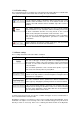
Route Planning Method types:
Button Description
Gives a quick route if you can travel at or near the speed limit on all
roads. Usually the best selection for fast and normal cars.
Gives a short route to minimise the distance to travel. Usually practical
for pedestrians, cyclists or slow vehicles. Searching for a short route
regardless of the speed, this route type is rarely practical for normal
vehicles.
Gives a quick but fuel efficient route based on the fuel consumption
data given in Route settings (page 72). Travel cost and CO
2
emission
calculations are estimations only. They cannot take elevations, curves
and traffic conditions into account.
Results in a route with fewer turns and no difficult manoeuvres. With
this option, you can make iGO primo to take, for example, the
motorway instead of a series of smaller roads or streets.