
User's Manual
IDS Ingegneria Dei Sistemi S.p.A. N doc: MN/2009/071 - Rev. 1.1
IBIS-S v. 1.0 - User Manual
44 / 48
A
ll information contained in this document is property of IDS. All rights reserved.
To avoid making projection errors of the displacement
data and when possible, we
recommend positioning the sensor so that the displacement direction of the interested
object occurs along the line that joins the point to the sensor.
If this is not possible, in order to minimise projection errors, an accurate georeferencing of
the sensor must be performed with respect to the scenario/structure of interest.. Maps of
the scenario and /or drawings of the buildings to be observed (in 3D if possible) should be
obtained.
If the monitoring concerns a public building or infrastructure , make sure that all required
authorisations have been obtained. It is always a good idea however to warn the
responsible local authority before starting to perform measurements.
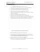
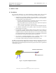
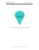
When extending the tripod to reach the desired height, the following basic precautions
should be taken to optimise the rigidity of the structure:
• Adjust the height of the structure by first lengthening the middle section of the
legs, then the thinner bottom sections;
• If possible, avoid extending the central column;
• Avoid opening the legs wide when they have been significantly extended in
length.
Fig. 6.2 – Tripod
6.2 U
se
When the equipment is functioning, it is a good idea
to ensure that nobody can pass or
stop in front of the radar sensor to avoid a reduction in the quality of the radar acquisition.
When performing a field measurement campaign , it is very useful to have a folding table
where the control and acquisition PC can be positioned.
Middle
section
Bottom
section
Central
column
Handle for
controlling the
central column