
User's Manual

4
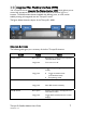
Thuraya IP+ Satellite Modem User Guide
3500799-0001 rev A
Note: You may want to store this as a browser bookmark.
2. If you have PIN security enabled on your SIM, you will be prompted to enter your
PIN before proceeding.
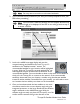
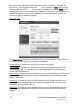
Note: You must have a valid GPS location for the compass direction and
Antenna Angle to be displayed. If the GPS is not valid, go back to step 3
to obtain a GPS fix.
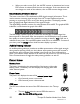
3. Look at the wMMI home page display and note the
compass bearings and elevations for both Thuraya IP+
satellites in the “Satellite Location” section. The
recommended satellite for your location will be highlighted
in green. With the Thuraya IP+ terminal upside down, use
the integrated compass to determine the direction of the
recommended satellite. You must be able to obtain a clear view of the satellite in
the sky for the Thuraya IP+ to connect to the network. If the recommended
satellite is obstructed from your location, consider using the alternate satellite
instead. If neither satellite is accessible from your location, you will need to move
to a location that has visibility to at least one of the satellites.
4. Once you have determined the best satellite to use, move
the antenna stand to the correct elevation angle using the
integrated protractor on the hinge. Recall that the elevation
angle is indicated on the wMMI home page. With the
elevation angle correctly set, place the Thuraya IP+ on a flat
surface with the antenna facing in the direction of the
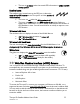
URL address field
Com
p
ass Direction
Antenna Angle