
User's Manual


8
User Manual
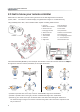
Map
Center
Map lock
Select Flight
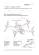
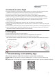
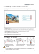
7.0 APP Operating Main Interface Instructions
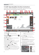
On the interface, HD video and photographs can be previewed in realtime and you can set the
dynamic parameters, such as aircraft, remote controller, gimbal and battery.
1. Return Home [ ]: Click it, the aircraft stops waypoints flying, and
return back automatically.
2. Auto Takeoff [ ]: Click it, the aircraft takes off automatically.
3.
Function box [ ]: Gesture shot, Active Track, and Aerial Modes.
4 . Battery level return [ ]: When the residual battery level reach ,
aircraft will automatically return back.
5. Back [ ]: Back to last step.
6. Device connection status: Display connected or disconnected.
7. Flight time [ ]: Aircraft flight time
8. The aircraft model: Displays aircraft’s flight mode.
9. Number of aircraft satellite [ ]: Displays the received satellites of aircraft.
10. Positioning accuracy [ ]: Displays aircraft positioning accuracy.
11. Remote controller signal and battery level[ ]
12. Transmission signal strength[ ]
13. Battery level [ ]: Real-time display of current smart flight
battery’s remaining level (voltage can be customizable)
14. Setting [ ]: Click the icon to open the setting menu to perform general
settings, settings for aircraft, remote controller, gimbal & battery
15. Camera setting [ ]: Click the icon to show professional, image, video and
other settings. Under the same resolution, the higher the code rate is, the
better the image quality is, and the video transmission distance can be
accordingly reduced.
16. Photo & video switch [ ]:
Photo: Photo button is used to trigger the camera to take pictures.
While this function is also supported in the remote
controller.
Video: video button to start/stop video. You can also press the
video button on the remote controller for video.
17. Video display [ ]
18. GPS positioning status: When connected, “GPS
positioning” appears; when disconnected, “GPS not positioning”
appears.
19. Flight status parameters:
Distance: horizontal distance between aircraft and returning point.
Height: vertical distance between aircraft and returning point.
Horizontal speed: speed of aircraft in a horizontal direction.
Vertical speed: speed of aircraft in the vertical direction.
20. A thumbnail map icon: Click the thumbnail icon to quickly
switch to the map interface.
Before you plan to fly, turn off the aircraft power,
and connect wifi, click "A thumbnail map icon"
to download the map.
GestureShot ActiveTrack Aerial Mode
G eady