
User Manual

2.3.2 Position Coordinate
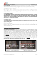
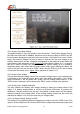
The current coordinate positioned by GPS is shown on the bottom-right corner. The upper
value is the , and is on the bottom. You will observe these two values are keep updating
during the flight as your plane is keep moving in the air. In case the GPS module
connection is broken, the latest position coordinate will be frozen to remind pilot the
position that the GPS positioning is lost. In the same time, the flashing “GPS Fail” will be
indicated in the GPS status. If the GPS is reconnected after the failure, the flashing “GPS
Fail” will be changed to “Searching...”, until the position is re-locked. Similarly, if the GPS
signal is not strong enough to provide a locking of position, the last measured position
coordinate will be frozen on the screen, and warns the pilot with flashing “Position Lost”,
until the GPS positioning is back to normal.
2.3.3 Main Sea Level Altitude
The main sea level altitude (MSLA) value indicates the current altitude measured
referencing from the sea level. This value is provided by the GPS module, and can be
corrected by the pressure altitude module that will be released in early future.
2.4 Flight Information
The flight information indicates the real-time flight parameters. The FPV plane pilots may
use these data to guide their flight.
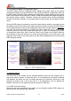
2.4.1 Compass
The plane heading direction is indicated by the virtual compass. This reading is provided
by the GPS module by calculating the direction of the plane travelling speed. The reading
has no meaning if the plane is static, unless the installation of the It can be optional
magnetic compass module, which will be released in early future.
2.4.2 Direction Heading
The real-time direction heading is denoted in the form of numerical number in the direction
heading reading. A zero degree means the plane is flying towards north direction.
2.4.3 Home Direction
If more than 10KM/H or equivalent in MPH speed is measured by the GPS for not less
than half of a second, the system will switch the operating mode from “Landed” mode to
“Taken-Off” mode. The system will always compare between the current position
coordinate and the position measured in “Landed” mode, and calculate the “Home
Direction”, hence advices the pilot where the plane took off referencing to the current flying
heading. If you are lost yourself during the flight, you may always fly back to the take-off
location by the referencing of home direction arrow.
2.4.4 Relative Altitude
The relative altitude is the altitude reading referencing to the altitude measured during the
“Landed” mode. It indicates the current hight above taken-off ground.
2.4.5 Altitude Scale
Beside the altitude indication in the relative altitude numerical reading, the dynamic of the
altitude change can be observed in the form of moving scale in the altitude scale.
AEO TECHNOLOGY www.aeorc.cn
Entire Contents © Copyright 2010 12 V1.03