
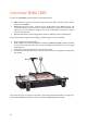
User's Guide

15
Some points to consider:
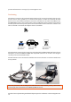
• If working in an environment with a number of trees, high buildings or other
infrastructure that might disturb the communication with GPS satellites, a Total Station is
preferred. In these types of environments, it can also be hard to define lines and point
features with the GPS.
• However, on open ground with lower vegetation and/or fewer overhead obstacles, the
RTK GPS solution is most often a faster and easier method of positioning.
• The Total Station needs line of sight and possibly an extra operator for the Total Station if
the tracking fails.
• If the investigation area is large, the Total Station may need to be moved and new Total
Station positions defined, which can be more time consuming. However, every type of
investigation area can be covered by a Total Station which is not the case with a GPS.
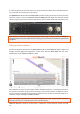
It should also be mentioned that temporary loss of tracking will not cause the data to be useless,
provided the start and end points of each swath are well defined.
Note: A GPS is very effective when it works!
In order to be 100% sure that you can perform the investigation a Total Station maybe
required.
Note: Measurements can be carried out without any positioning system but is not generally
recommended unless absolutely necessary. The measurement lines should be straight and
with an even spacing so coordinate files for post-processing software can be created
afterwards.
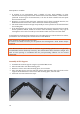
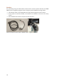
Assembly of GPS Support
• Assemble the antenna support using the 6 provided M6 screws.
• Place the GPS rod in the GPS mounting plate.
• Remove 6 screws on the GPS mounting plate, 3 on each side.
• Place the GPS support over the GPS rod and the GPS mounting plate. The holes on the
support should match the screws on the GPS mounting plate, 2 on each side.
• Attach the 6 screws removed in step 3.