
User's Guide

14
provide information on coverage of your investigation area.
Positioning
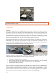
The antenna array must be positioned with a high level of accuracy throughout the survey. A
precise control of the geometry is an absolute prerequisite to make the resulting 3D radar
picture correct and reliable. Centimetre accuracy is needed over the whole investigation site.
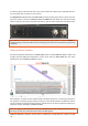
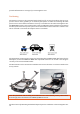
The MIRA HDR system can be positioned by using an RTK GPS system and with a Total station
solution (in the near future). The system can be used without a base station if a suitable rover
unit is used and a correction subscription service is available.
The positioning system needs to export the positioning data in NMEA 0183 GGA format for the
GPS option, so that the MIRAsoft HDR data acquisition software can record it and assign it
correctly to the measured GPR swaths.
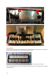
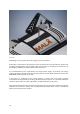
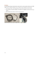
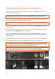
The GPS antenna can be connected to Guideline Geo carrier solutions or can be mounted on the
survey vehicle:
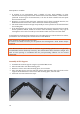
Note: The placement and recording of the GPS antenna or Total Station prism’s position must
be thorough; this is described in the MIRAsoft HDR User Guide.
The best choice of positioning method will depend upon the conditions at the investigation site.