
User's Manual

34
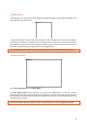
appear on the vertical curser which can be positioned at the correct depth by using the Navigator
control.
Hide removes the markers from the display. This is not permanent; the markers can be made
visible again by selecting Show, which is indicated after Hide is selected.
Select Cancel to exit the Marker Menu.
Note: Markers are saved in a text file with the extension *.mrk. This file get the same name as the
data file.
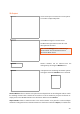
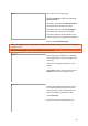
Select Tools to enter the Tools Menu.
A dropdown menu appears when the Tools Icon is selected.
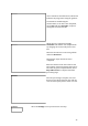
Set Soil velocity. If the soil velocity has been determined, enter the value by selecting Set Soil
Velocity icon and then use the Navigator to set the correct figure.
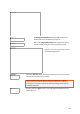
Depth Calibration. If the true depth of an item is known, place the antenna so the vertical curser
is positioned over the feature in the radargram, select Depth Calibration to activate the cross-
hair and use the Navigator to position the horizontal curser at the top of the reflector with known
depth. Press the Navigator and enter the value for the true depth. Finally, press the Navigator
again to accept the value and the GX Controller will automatically calculate the velocity based on
the entered value.
Hyperbola fitting. If there is a clear hyperbolic response in the radargram, utilise the Hyperbola
fitting feature to calculate the velocity of the soil. Position the antenna so the vertical curser is
over the hyperbola, press the Navigator to activate the horizontal crosshair and rotate the
Navigator to place the cross-hair on the top of the hyperbola. Press the Navigator to reveal the
simulated hyperbola, now rotate the Navigator to increase or decrease the simulated hyperbola
so it “fits” the true hyperbola in the radargram. Press the Navigator to complete the process; the
calculated velocity will be saved.
Tip: To move the crosshair up and down faster, press down the Navigator and rotate at the same
time.
Migration. This option applies migration to the dataset, which will have the effect of removing
the hyperbola to leave a point in the radargram. First, complete any of the above velocity
calculations to determine the soil velocity and then select Migration to apply the process to the
radargram.
Tip: Accurate calculation of the soil velocity is required for the migration to work effectively.
Depth Calibration is often the most accurate and this should be the first option if available.