
User's Manual

19
5.2
SettingsintheGIStarsoftware
5.2.1
Projectsettings
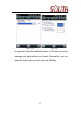
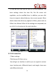
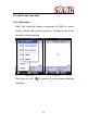
①Createaproject
Click
Manage/Project/New Project. Then a project description
interface pops up, where you need to input the project
nameandchooseastoragepathforthenewproject.
Figure5‐2
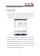
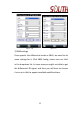
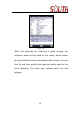
②Cl ick Next and choose coordinate system. The default
system is Beijing54. In many cases, you may require other
differentcoordinatesystems,soyoucanclickEdittomodify
somedefaultvaluesandgetanewsystem.The
Editinterface
includes
Ellipsoid, Projection, Seven, Four, Altitude, Vertical and
Correctionitemforparameterssettings.