
Users Manual

NUSITE
NUSEIS
Geophysical Technology Inc NuSite Page | 22
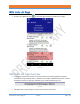
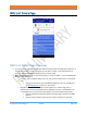
Map Screen Use
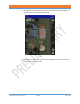
• Current position of the device is displayed as a blue dot surrounded by white.
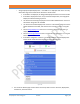
• To navigate to a receiver point and corresponding NRU node:
o Select a map zoom level that displays both the receiver point to navigate to, and the
current position dot.
o Make sure the centering bullseye icon is lit green.
o Move towards the targeted receiver point, adjusting zoom appropriately, until the NRU
node icon appears on the screen at the targeted receiver point.
➢ Note: Never perform adjustments or allow distraction by the NuSite device when
operating a motor vehicle or ATV. If zoom adjustment needs to be made, always stop
the vehicle in a safe place and manner prior to adjusting the NuSite device.
➢ When walking with a NuSite device, take care not to allow attention to the screen to
cause a trip or fall.
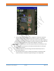
• Once the targeted receiver point has been reached and the corresponding NRU node is visible
on the screen, tapping on the NRU-1C symbol will open the NRU details screen for that NRU. See
the NRU Unit Details section for more information.
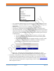
Map Layer Images
• Map layer images are loaded onto NuSite via synchronization with NuScribe. Only images that
have been loaded onto NuScribe will be visible on NuSite.
• If no extra images have been loaded onto NuScribe, then the only map layer that will be loaded
to NuSite will be the low resolution world view.
• During synchronization with NuScribe, the last task in the synchronization is the map layer
images.
• See the NuScribe manual Map View Layers section for information on loading map image layers
to NuScribe.