
User's Manual
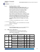
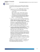
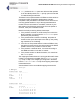
Table Of Contents
- Chapter 1 Introduction
- Chapter 2 Mesh Point CLI and Administrative Access
- Chapter 3 Networking and Radio Configuration
- 3.1 Network Interfaces
- 3.2 Network Bridging
- 3.2.1 Bridging Configuration
- 3.2.2 FastPath Mesh Bridging
- 3.2.3 Fine-tuning FastPath Mesh Network Performance
- 3.2.3.1 Selecting the FastPath Mesh Multicast Transmit Mode
- 3.2.3.2 Setting the FastPath Mesh Packet Interval
- 3.2.3.3 Setting the FastPath Mesh Transmit Control Level
- 3.2.3.4 Setting Multicast Video Clamping Thresholds
- 3.2.3.5 Setting Mesh Routing Reactivity
- 3.2.3.6 Setting Mesh Packet Time To Live
- 3.2.3.7 Viewing Current Mesh Performance Parameters
- 3.2.3.8 Frame Processor Parameters
- 3.2.4 STP Bridging
- 3.3 Global Radio Settings
- 3.4 Individual Radio Settings
- 3.4.1 Radio Band, Short Preamble, Guard Interval
- 3.4.2 Channel Selection
- 3.4.3 Distance, Beacon Interval, Noise Immunity
- 3.4.4 Network Type, Antenna Gain, Tx Power
- 3.4.5 MIMO
- 3.4.6 STBC
- 3.4.7 Channel Lock and Other Channel Selection Features
- 3.4.8 DFS, TDWR, and Channel Exclusion
- 3.4.9 Radio BSS Settings
- 3.4.9.1 BSS Radio, BSS Name and SSID
- 3.4.9.2 WDS Bridging or AP Infrastructure Configuration
- 3.4.9.3 BSS State, SSID Advertising and Drop Probe Requests
- 3.4.9.4 BSS STA Idle Timeout and 802.11g-Only Settings
- 3.4.9.5 BSS Unicast Transmission Rate Settings
- 3.4.9.6 BSS WMM QoS Setting
- 3.4.9.7 BSS Fragmentation and RTS Thresholds
- 3.4.9.8 BSS DTIM Beacon Countdown
- 3.4.9.9 BSS VLANs Settings
- 3.4.9.10 BSS Fortress Security Zone
- 3.4.9.11 FastPath Mesh BSS Cost Offset
- 3.4.9.12 BSS Multicast Settings
- 3.4.9.13 Bridging MTU and Beacon Encryption
- 3.4.9.14 BSS Description
- 3.4.9.15 BSS Wi-Fi Security Configuration
- 3.4.10 Antenna Tracking / Rate Monitoring
- 3.4.11 ES210 Mesh Point STA Settings and Operation
- 3.4.11.1 STA Radio, Name, SSID and SSID Roaming
- 3.4.11.2 STA State
- 3.4.11.3 STA Unicast Transmission Rate Settings
- 3.4.11.4 STA Background Scanning
- 3.4.11.5 STA WMM QoS Setting
- 3.4.11.6 STA Fragmentation and RTS Thresholds
- 3.4.11.7 STA Multicast Rate
- 3.4.11.8 STA Description
- 3.4.11.9 STA Wi-Fi Security Configuration
- 3.4.11.10 Editing or Deleting a STA Interface Connection
- 3.4.11.11 Establishing a STA Interface Connection
- 3.4.11.12 ES210 Station Access Control Lists
- 3.5 Local Area Network Configuration
- 3.6 Time and Location Configuration
- 3.7 GPS and Location Configuration
- 3.8 DHCP and DNS Services
- 3.9 Ethernet Interfaces
- 3.10 Quality of Service
- 3.11 VLANs Implementation
- 3.12 ES210 Mesh Point Serial Port Settings
- 3.13 Mesh Viewer Protocol Settings
- Chapter 4 Network Security, Authentication and Auditing
- 4.1 Fortress Security Settings
- 4.1.1 Operating Mode
- 4.1.2 FIPS Settings
- 4.1.3 MSP Encryption Algorithm
- 4.1.4 Encrypted Data Compression
- 4.1.5 MSP Key Establishment
- 4.1.6 MSP Re-Key Interval
- 4.1.7 Key Beacon Interval
- 4.1.8 Fortress Legacy Devices
- 4.1.9 Encrypted Zone Cleartext Traffic
- 4.1.10 Encrypted Zone Management Settings
- 4.1.11 Authorized Wireless Client Management Settings
- 4.1.12 Turning Mesh Point GUI Access Off and On
- 4.1.13 SSH Access to the Mesh Point CLI
- 4.1.14 Blackout Mode
- 4.1.15 Allow Cached Credentials
- 4.1.16 Fortress Access ID
- 4.2 Digital Certificates
- 4.3 Access Control Entries
- 4.4 Internet Protocol Security
- 4.5 Authentication and Timeouts
- 4.5.1 Authentication Servers
- 4.5.2 Internal Authentication Server
- 4.5.2.1 Basic Internal Authentication Server Settings
- 4.5.2.2 Certificate Authority Settings
- 4.5.2.3 Global User and Device Authentication Settings
- 4.5.2.4 Local 802.1X Authentication Settings
- 4.5.2.5 OCSP Authentication Server Settings
- 4.5.2.6 OCSP Cache Settings and Management
- 4.5.2.7 Internal Authentication Server Access Control Lists
- 4.5.3 User Authentication
- 4.5.4 Client Device Authentication
- 4.5.5 Session Idle Timeouts
- 4.6 ACLs and Cleartext Devices
- 4.7 Remote Audit Logging
- 4.8 Wireless Schedules
- 4.1 Fortress Security Settings
- Chapter 5 System Options, Maintenance and Licensing
- Chapter 6 System and Network Monitoring
- Index
- Glossary

Fortress ES-Series CLI Guide: Networking and Radio Configuration
86
3.7 GPS and Location Configuration
Only the ES2440 and ES210 Mesh Points are equipped with
an internal GPS receiver that, when enabled and connected to
a GPS antenna, permits the Mesh Point to use the signals of
GPS satellites in range to triangulate its exact position on the
globe. The internal GPS is
disabled
by default.
The ES820 and ES520 Mesh Points can be equipped with
external GPS receivers. Fortress Mesh Point Hardware Guides
for these models provide details on supported devices. Install
external USB GPS receivers according to their manufacturers’
instructions. After installing an external GPS receiver, you must
enable it.
Enable the internal GPS or an external GPS receiver with the
set location command:
# set location -mode gps
View the current location with show location:
# show location
Mode: gps
Fix type: 3D
Latitude: 42°34'17.659"N
Longitude: 71°24'44.180"W
Altitude: 93 meters
Speed: 0.0000 m/s
Satellites: 8
Last Fix: Tue Mar 23 13:46:42 2010
The Mode indicates whether the location will be determined by
the GPS, or set manually.
The
Fix type indicates how many, if any, GPS satellites are
within the Mesh Point’s range and whether or not the Satellite
Based Augmentation System (SBAS) was used to determine
the Mesh Point’s location:
Unavailable
: No satellites are within range and no fix is
obtainable.
2D
or
2D SBAS
: A limited number of satellites are within
range. A fix is obtainable, but the location is not as accurate
as when the fix type is
3D
or
3D SBAS
.
3D
: Indicates that enough satellites are available to get
accurate longitude, latitude, and altitude readings.
3D SBAS
: The most accurate fix type. It indicates that
enough satellites are available to get accurate longitude,
latitude, and altitude readings and that the SBAS was used
to determine the location.