
User's Manual
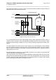
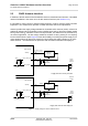
Table Of Contents

Cinterion
®
AGS2-E Hardware Interface Overview
4 GNSS Receiver
27
AGS2-E_HIO_v00.021 2014-03-20
Confidential / Preliminary
Page 27 of 40
4 GNSS Receiver
AGS2-E integrates a GPS receiver that offers the full performance of GPS technology. The
GPS receiver is able to continuously track all satellites in view, thus providing accurate satellite
position data.
The integrated GPS receiver supports the NMEA protocol via ASC0 interface. NMEA is a com-
bined electrical and data specification for communication between various (marine) electronic
devices including GPS receivers. It has been defined and controlled by the US based National
Marine Electronics Association. For more information on the NMEA Standard please refer to
http://www.nmea.org.
Depending on the receiver’s knowledge of last position, current time and ephemeris data, the
receiver’s startup time (i.e., TTFF = Time-To-First-Fix) may vary: If the receiver has no knowl-
edge of its last position or time, a startup takes considerably longer than if the receiver has still
knowledge of its last position, time and almanac or has still access to valid ephimeris data and
the precise time.
By default, the GPS receiver is switched off. It has to be switched on and configured using AT
commands (AT^SGPSC; see [1]).
GPS 1pps Clock:
AGS2-E provides a high accuracy 1pps output (one pulse per second) signal, synchronized
with the GPS time.
The 1pps output can be used by an external application as a reference to generate accurate
high-frequency clocks. A specific design however has to address the short-term jitter affecting
the 1pps signal. As a general rule, the divided system clock is synchronized with the GPS 1pps
for the long-term accuracy. The deviation is less than 50ns.
The 1pps signal is based on the almost-perfect timing of the satellite. But as the satellite moves,
the distance to it will increase or decrease. This change in distance will produce a change in
the 1pps signal, because the light has to travel a different distance each time.
To compensate for this effect the GNSS (Global Navigation Satellite System) has to know its
position. Then it is able to correct signal effects (mainly distance but there are more). Therefore,
at least three satellites are required (better four).