
Guide


XMap 7 Network and Silent Installs
Contact DeLorme Professional Sales for support: 1-800-293-2389 Page 82
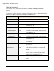
Optional Feature List
These features can be configured using the INSTALL_FEATURES, and DISABLE_FEATURES
properties.
Symbols: ‘-‘ Indicates a sub feature. The number of ‘-‘ symbols indicate the level of the sub feature. If the
parent feature is disabled, then all the child features are disabled. For example, disabling SampleImagery
disables ExplorersMonumentAZ, FontanaLakeNC, JennyLakeWY, and etc.
Feature Name Default Action Notes
SampleData Install Installs complete collection of sample data.
-SampleImagery Install Installs sample imagery.
--ExplorersMonumentAZ Install Color Aerial Imagery and USGS 1:24K Topo Quads
(scanned maps) for Explorer’s Monument, AZ
--FontanaLakeNC Install Color Aerial Imagery and USGS 1:24K Topo Quads
for Fontana Lake, NC
--JennyLakeWY Install Color Aerial Imagery and USGS 1:24K Topo Quads
for Jenny Lake, WY
--MtWashingtonNH Install Color Aerial Imagery and USGS 1:24K Topo Quads
for Mt. Washington, NH
--SilvertonCO Install Color Aerial Imagery and USGS 1:24K Topo Quads
for Silverton, CO
--SkylineDriveVA Install Color Aerial Imagery and USGS 1:24K Topo Quads
for Skyline Drive, VA
--YellvilleAR Install Color Aerial Imagery and USGS 1:24K Topo Quads
for Yellville, AR
--YosemiteCA Install Color Aerial Imagery and USGS 1:24K Topo Quads
for Yosemite, CA
-SampleDraw Install Examples of draw files.
-SampleGPSLogs Install Sample GPS log files that can be viewed with the
GPS tab.
-SampleXData Install Installs sample XData files for import. Use as an
example of how to format your own files. XData is
available for Plus and Plus Network only.
DesktopShortcut Install Creates a desktop shortcut
AutoCheckUpdate Install Configures NetLink to automatically check for
updates.