
Guide


Importing From ArcSDE
Contact DeLorme Professional Sales for support: 1-800-293-2389 Page 103
Importing Using the Import Wizard
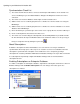
To import from ArcSDE using the GIS import wizard, open the wizard and select the Database option at
the top of the first page. In the Connect to Database page, provide the server name and instance (For
example SDE_Server:5151), and login and password. Then click the Search button.
Note: If the ArcSDE database is on an Oracle server, the search function will not work and the name of
the database must be manually specified.
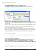
Once a connection to the server is successfully established, select the geodatabase from which to import
from, and then click OK to return to the normal import wizard process. You will need to select which layer
in the connected database you would like to import.
See the XMap Help section Importing a Layer from an ArcSDE Database for more detailed information.
Importing Using the Bulk Importer
The Bulk Importer parameters are already well documented in the Bulk Importing Parameters section of
the Help system. However, there are two other advanced features which bear mentioning.
First, for optimal performance make sure that the layer entity mask is set to properly reflect the types of
objects contained within the layer. If the mask is set to include multiple geometry types, then a more
expensive test must be performed by the importer to verify the layer geometry type.
Second, the ability to filter imports is available through an environment variable named
“OGR_SDE_ATTRIBUTEFILTER”. This variable receives an arbitrarily complex WHERE clause which is
used when reading shapes from the ArcSDE database. This mechanism can be used to filter the
incoming layer by spatial criteria as in the included example (see sample.cmd). Please verify any SQL
statements prior to using them within an attribute filter as the error messages reported by the ArcSDE
client API do not include any details regarding the source of the problem.
sample.cmd
SET OGR_SDE_ATTRIBUTEFILTER=SDO_FILTER(SHAPE,SDO_GEOMETRY(2003,1777001,null,S
DO_ELEM_INFO_ARRAY(1,1003,3),SDO_ORDINATE_ARRAY(2132287.42350376,11978325.021
9199, 2301399.45371734, 12139499.088350))) = 'TRUE'
Another example of how to use the attribute filter is to filter the data by one of the attributes in the
database for example SET OGR_SDE_SDE_ATTRIBUTE=STATE=’TX’ where STATE is one of the
attributes in the imported layer.
Lastly, there is a system variable that can be use to limit the extent of the import. It is called
OGC_SDE_ENVELOPEFILTER and the parameters are Minlon, Maxlon, MinLat,MaxLon. Remember that
this setting will filter all imports so remove this setting if you want to import a different layer outside the
current set extent.