
User manual
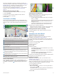

Table Of Contents
- Table of Contents
- Getting Started
- Installation
- Off-Road Navigation Features
- Using the Map
- Using the Apps
- Live Services, Traffic, and Smartphone Features
- Bluetooth Feature Status Icons
- Pairing Your Phone and Headset
- Smart Notifications
- Hands-Free Calling
- Setting Up Bluetooth Features for Your Apple® Device
- Setting Up Bluetooth Features for Your Smartphone with Android™
- Enabling or Disabling Bluetooth Features for Your Headset
- Disconnecting a Bluetooth Device
- Deleting a Paired Phone
- Street Navigation
- Finding and Saving Locations
- Finding a Location Using the Search Bar
- Points of Interest
- Finding a Location by Category
- Viewing Your Garmin Explore Points of Interest
- Location Search Results
- Changing the Search Area
- Finding Parking Near Your Current Location
- Finding Parking Near a Specified Location
- Search Tools
- Finding HISTORY Points of Interest
- Finding National Parks
- Finding Ultimate Campgrounds Points of Interest
- Finding iOverlander™ Points of Interest
- Finding Powersport Points of Interest
- Tripadvisor
- Viewing Recently Found Locations
- Viewing Current Location Information
- Adding a Shortcut
- Saving Locations
- Rider Awareness Features and Alerts
- Settings
- Device Information
- Device Maintenance
- Troubleshooting
- My device is not acquiring satellite signals
- My battery does not stay charged for very long
- My device does not connect to my phone
- My device does not appear as a removable drive on my computer
- My device does not appear as a portable device on my computer
- My device does not appear as either a portable device or a removable drive or volume on my computer
- Appendix
- Garmin PowerSwitch
- Wireless Cameras
- Installing a Memory Card for Maps and Data
- Data Management
- Viewing GPS Signal Status
- Purchasing Additional Maps
- Index

each alert. You can enable or disable the audible tone or
message for each type of alert. Not all alerts are available in all
areas.
School zone or nearby school: The device plays a tone and
displays the distance to and speed limit (if available) for an
upcoming school or school zone.
Speed limit reduction: The device plays a tone and displays
the upcoming reduced speed limit so you can be prepared to
reduce your speed.
Speeding alert: The device plays a tone and displays a red
border on the speed limit icon when you exceed the posted
speed limit for the current road.
Railroad crossing: The device plays a tone and displays the
distance to an upcoming railroad crossing.
Animal crossing: The device plays a tone and displays the
distance to an upcoming animal crossing area.
Curve: The device plays a tone and displays the distance to a
curve in the road.
Slower traffic: The device plays a tone and displays the
distance to slower traffic when you approach slower traffic at
a higher speed. Your device must be receiving traffic
information to use this feature.
Enabling or Disabling Rider Alerts
You can turn off individual audible rider alerts. Visual alerts
appear even when the audible alert is disabled.
1
Select > Driver Assistance > Rider Alerts.
2
Select or clear the check box next to each alert.
Red Light and Speed Cameras
NOTICE
Garmin is not responsible for the accuracy of or the
consequences of using a red light or speed camera database.
NOTE: This feature is not available for all regions or product
models.
Information about red light and speed camera locations is
available in some areas for some product models. The device
alerts you when you approach a reported speed or red light
camera.
• In some areas, your device can receive live red light and
speed camera data while connected to a smartphone running
the Tread app.
• You can use the Garmin Express
™
software (garmin.com
/express) to update the camera database stored on your
device. You should update your device frequently to receive
the most up-to-date camera information.
Fuel Tracking
You can set your device to estimate your fuel usage, warn you
when you approach the maximum estimated fuel distance, and
suggest fuel stops based on your estimated fuel range. When
fuel tracking is enabled, indicates the current fuel status.
White: Fuel tracking is disabled, or the device is not connected
to the mount.
Green: The estimated fuel range is above the fuel tank warning
level.
Yellow: The estimated fuel range is below the fuel tank warning
level.
Red: The estimated distance remaining on the tank is 0.
Enabling Fuel Tracking
Before you can enable fuel tracking, the device must be in ATV,
side-by-side, snowmobile, or motorcycle mode and placed in the
mount.
When you enable fuel tracking, a fuel gauge appears on the trip
computer (Viewing the Trip Information Page, page 8).
1
Fill your fuel tank.
2
Select > Fuel Settings > Fuel Tracking.
3
Select Distance Per Tank.
4
Enter the distance the vehicle travels on a tank of gas and
select Done.
Setting a Low Fuel Warning
You can set the device to warn you when the tank is low on fuel.
NOTE: The device must be connected to the mount to give low
fuel warnings.
1
Enable fuel tracking (Enabling Fuel Tracking, page 21).
2
Select Remaining Fuel Warning.
3
Enter a distance, and select Done.
When you have only enough fuel left to travel the distance you
entered, a low fuel warning appears on the map page.
Resetting the Fuel Tank Mileage
When you refill your fuel tank, you should reset the fuel tank
mileage on your device to more accurately track your remaining
fuel.
Select > Fuel Settings > Reset Fuel Tank.
Viewing Helmet Law Notifications
While you are using a motorcycle vehicle profile, helmet law and
eye protection notifications may appear on your Tread device.
Notifications appear the first time your device acquires satellites
and when your device approaches a location with motorcycle
safety rules.
NOTICE
Garmin recommends that all riders wear helmets for safety.
Helmet law notifications are for reference only, are subject to
change, and are not intended to be considered legal advice.
Helmet law notifications are available in the U.S. and Canada
only.
Select the notification to view more details.
Searching for Helmet Laws
You can search for helmet laws by state or province.
1
Select > Helmet Guide.
2
Select a state or province.
Settings
Map and Vehicle Settings
Select > Map Display.
Map Vehicle Icon: Sets the vehicle icon that represents your
position on the map.
Driving Map View: Sets the perspective on the map.
Map Detail: Sets the level of detail on the map. More detail may
cause the map to draw slower.
Street Map Theme: Changes the color of the map data.
Map Layers: Sets the data that appears on the map page
(Customizing the Map Layers, page 9).
Auto Zoom: Automatically selects the zoom level for optimal
use of your map. When disabled, you must zoom in or out
manually.
Skip Next Stop Confirmation: Sets a confirmation message to
appear when skipping a location on your route.
myMaps: Sets which installed maps the device uses.
Settings 21