
User manual
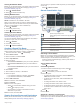

Table Of Contents
- Table of Contents
- Getting Started
- Installation
- Off-Road Navigation Features
- Using the Map
- Using the Apps
- Live Services, Traffic, and Smartphone Features
- Bluetooth Feature Status Icons
- Pairing Your Phone and Headset
- Smart Notifications
- Hands-Free Calling
- Setting Up Bluetooth Features for Your Apple® Device
- Setting Up Bluetooth Features for Your Smartphone with Android™
- Enabling or Disabling Bluetooth Features for Your Headset
- Disconnecting a Bluetooth Device
- Deleting a Paired Phone
- Street Navigation
- Finding and Saving Locations
- Finding a Location Using the Search Bar
- Points of Interest
- Finding a Location by Category
- Viewing Your Garmin Explore Points of Interest
- Location Search Results
- Changing the Search Area
- Finding Parking Near Your Current Location
- Finding Parking Near a Specified Location
- Search Tools
- Finding HISTORY Points of Interest
- Finding National Parks
- Finding Ultimate Campgrounds Points of Interest
- Finding iOverlander™ Points of Interest
- Finding Powersport Points of Interest
- Tripadvisor
- Viewing Recently Found Locations
- Viewing Current Location Information
- Adding a Shortcut
- Saving Locations
- Rider Awareness Features and Alerts
- Settings
- Device Information
- Device Maintenance
- Troubleshooting
- My device is not acquiring satellite signals
- My battery does not stay charged for very long
- My device does not connect to my phone
- My device does not appear as a removable drive on my computer
- My device does not appear as a portable device on my computer
- My device does not appear as either a portable device or a removable drive or volume on my computer
- Appendix
- Garmin PowerSwitch
- Wireless Cameras
- Installing a Memory Card for Maps and Data
- Data Management
- Viewing GPS Signal Status
- Purchasing Additional Maps
- Index

Adjusting the Radio Volume
1
Select Radio > .
2
Use the slider bars to adjust the volume.
Radio Settings
From the main menu, select Radio > .
Push to Talk with Headset: Enables you to transmit your voice
using the push-to-talk button on your compatible headset.
Roger Tone: Sets the roger tone the device plays when you
operate your radio.
Reset Default Settings: Resets all radio settings and presets to
factory default values.
inReach
®
Remote
The inReach remote function allows you to control your inReach
satellite communication device (sold separately) using your
Tread device. You can send messages, view weather reports,
trigger an SOS alert, and more. Go to buy.garmin.com to
purchase an inReach device.
Connecting an inReach Device
1
Bring the inReach device within 3 m (10 ft.) of your Tread
device.
2
On your Tread device, select > inReach.
3
Follow the on-screen instructions on your Tread device to
complete the pairing process.
After the pairing process is complete, the inReach and Tread
devices connect automatically when they are within range.
Sending an inReach Message
Before you can send an inReach message using your Tread
device, you must pair it with a compatible inReach device
(Connecting an inReach Device, page 7).
You can use your device to send inReach messages to your
contacts.
1
Select > inReach > .
2
Select New Message.
3
Select Select Contacts to add one or more contacts.
4
Enter a message.
5
Select Send.
SOS
During an emergency, you can contact the GEOS International
Emergency Rescue Coordination Center (IERCC) to request
help. Pressing the SOS button sends a message to the rescue
coordination center, and they notify the appropriate emergency
responders of your situation. You can communicate with the
rescue coordination center during your emergency while you
wait for help to arrive. You should only use the SOS function in a
real emergency situation.
Initiating an SOS Rescue
Before you can initiate an SOS rescue using your Tread device,
you must pair it with a compatible inReach device (Connecting
an inReach Device, page 7).
NOTE: While in SOS mode, the inReach device cannot be
turned off.
1
Select > inReach.
2
Select .
3
Wait for the SOS countdown.
The device sends a default message to the emergency
response service with details about your location.
4
Reply to the confirmation message from the emergency
response service.
Your reply lets the emergency response service know that
you are capable of interacting with them during the rescue.
For the first 10 minutes of your rescue, an updated location is
sent to the emergency response service every minute. To
conserve battery power after the first 10 minutes, an updated
location is sent every 10 minutes when moving, and every 30
minutes when stationary.
Canceling an SOS Rescue
If you no longer need assistance, you can cancel an SOS
rescue after it is sent to the emergency response service.
Select Cancel SOS > Cancel SOS.
Your device transmits the cancellation request. When you
receive a confirmation message from the emergency response
service, the device returns to normal operation.
Using the Map
You can use the map to navigate a route (Your Route on the
Map, page 15) or to view a map of your surroundings when no
route is active.
1
Select View Map.
2
Touch anywhere on the map.
3
Select an option:
• Drag the map to pan left, right, up, or down.
• To add or remove map layers such as topographic and
BirdsEye imagery, select .
• To zoom in or out, select or .
• To switch between North Up, 2-D, and 3-D views, select
.
• To start a route, select a location on the map, and select
Go! (Starting a Route by Using the Map, page 15).
Map Tools
Map tools provide quick access to information and device
functions while you view the map. When you activate a map
tool, it appears in a panel at the edge of the map.
Stop: Stops navigation of the active route.
Edit Route: Allows you to take a detour or skip locations in your
route (Changing Your Active Route, page 15).
Mute: Mutes the device audio.
Cities Ahead: Shows upcoming cities and services along your
active route or along a highway (Cities Ahead, page 8).
Up Ahead: Shows upcoming locations along the route or the
road on which you are traveling (Up Ahead, page 8).
Elevation: Displays elevation changes ahead.
Traffic: Displays traffic conditions along your route or in your
area (Viewing Upcoming Traffic, page 8). This feature is
not available in all areas or for all device models.
Trip Data: Displays customizable trip data, such as speed or
mileage (Viewing Trip Data from the Map, page 8).
Track Recorder: Displays the track data for your active route.
Turns: Displays a list of upcoming turns in your route (Viewing
Turns and Directions, page 15).
Phone: Displays a list of recent phone calls from your
connected phone, and displays in-call options while a phone
call is active (Using In-Call Options, page 14).
Weather: Displays weather conditions for your area.
Report Safety Camera: Allows you to report a speed or red
light camera. This tool is available only when you have speed
or red light camera data on your device and you have an
active connection to the Tread app (Pairing Your Phone and
Headset, page 13).
Music Player: Displays media controls and media information.
Pitch and Roll: Displays the current angle of your vehicle (Pitch
and Roll, page 5).
Using the Map 7