
User manual

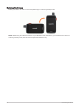


Table Of Contents
- Table of Contents
- Introduction
- inReach Features
- Viewing the Main Pages
- Connected Features
- Navigation
- Where To? Page
- Waypoints
- Saving Your Current Location as a Waypoint
- Saving a Location on the Map as a Waypoint
- Navigating to a Waypoint
- Finding a Waypoint
- Editing a Waypoint
- Deleting a Waypoint
- Changing the Photo for a Waypoint
- Increasing the Accuracy of a Waypoint Location
- Projecting a Waypoint from a Saved Waypoint
- Moving a Waypoint on the Map
- Finding a Location Near a Waypoint
- Setting a Waypoint Proximity Alarm
- Adding a Waypoint to a Route
- Repositioning a Waypoint to Your Current Location
- Routes
- Recordings
- Courses
- Weather
- Main Menu Applications
- Customizing the Main Menu
- Garmin Adventures
- Setting an Alarm
- Calculating the Size of an Area
- BirdsEye Imagery
- Camera and Photos
- Dog Tracking
- Using the Flashlight
- Geocaches
- Using the inReach Remote
- Marking and Starting Navigation to a Man Overboard Location
- Selecting a Profile
- Setting a Proximity Alarm
- Satellite Page
- Sending and Receiving Data Wirelessly
- Using the VIRB Remote
- Customizing the Device
- Custom Data Fields and Dashboards
- Rotating the Screen
- Setup Menu
- System Settings
- Display Settings
- Bluetooth Settings
- Wi‑Fi Settings
- Routing Settings
- Turning On Expedition Mode
- Setting the Device Tones
- Camera Settings
- Geocaching Settings
- Wireless Sensors
- Fitness Settings
- Marine Settings
- Menu Settings
- Position Format Settings
- Changing the Units of Measure
- Time Settings
- Accessibility Settings
- Profiles
- Resetting Data and Settings
- Device Information
- Appendix
- Index

Using the VIRB Remote
Before you can use the VIRB remote function, you must enable the remote setting on your VIRB camera. See the
VIRB Series Owner's Manual for more information.
The VIRB remote function allows you to control your VIRB action camera using your device.
1 Turn on your VIRB camera.
2 On your Montana device, select VIRB Remote.
NOTE: You may need to add this application to the main menu before you can select it (Customizing the Main
Menu, page 34).
3 Wait while the device connects to your VIRB camera.
4 Select an option:
• To record video, select .
• To take a photograph, select .
Customizing the Device
Custom Data Fields and Dashboards
Data fields display information about your location or other specified data. Dashboards are a custom grouping
of data that can be helpful to a specific or general task, such as geocaching.
Enabling the Map Data Fields
You can show custom data fields on the map.
1 From the map, select > Map Setup > Dashboard.
2 Select Large Data Field or Small Data Fields.
3 If necessary, on the map, select at the top of the screen to show the data fields.
Customizing the Data Fields
Before you can change the map data fields, you must enable them (Enabling the Map Data Fields, page 45).
You can customize the data fields and dashboards of the map, compass, trip computer, and altimeter pages.
1 From a page that displays data fields, select a data field.
2 Select a data field category and a data field.
Customizing Dashboards
1 Select a page.
2 Select an option:
• From the map, select > Map Setup > Dashboard.
• From the compass or trip computer, select > Change Dashboard.
3 Select a dashboard.
Customizing the Device 45