
User manual
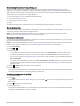
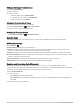
Table Of Contents
- Table of Contents
- Introduction
- inReach Features
- Viewing the Main Pages
- Connected Features
- Navigation
- Where To? Page
- Waypoints
- Saving Your Current Location as a Waypoint
- Saving a Location on the Map as a Waypoint
- Navigating to a Waypoint
- Finding a Waypoint
- Editing a Waypoint
- Deleting a Waypoint
- Changing the Photo for a Waypoint
- Increasing the Accuracy of a Waypoint Location
- Projecting a Waypoint from a Saved Waypoint
- Moving a Waypoint on the Map
- Finding a Location Near a Waypoint
- Setting a Waypoint Proximity Alarm
- Adding a Waypoint to a Route
- Repositioning a Waypoint to Your Current Location
- Routes
- Recordings
- Courses
- Weather
- Main Menu Applications
- Customizing the Main Menu
- Garmin Adventures
- Setting an Alarm
- Calculating the Size of an Area
- BirdsEye Imagery
- Camera and Photos
- Dog Tracking
- Using the Flashlight
- Geocaches
- Using the inReach Remote
- Marking and Starting Navigation to a Man Overboard Location
- Selecting a Profile
- Setting a Proximity Alarm
- Satellite Page
- Sending and Receiving Data Wirelessly
- Using the VIRB Remote
- Customizing the Device
- Custom Data Fields and Dashboards
- Rotating the Screen
- Setup Menu
- System Settings
- Display Settings
- Bluetooth Settings
- Wi‑Fi Settings
- Routing Settings
- Turning On Expedition Mode
- Setting the Device Tones
- Camera Settings
- Geocaching Settings
- Wireless Sensors
- Fitness Settings
- Marine Settings
- Menu Settings
- Position Format Settings
- Changing the Units of Measure
- Time Settings
- Accessibility Settings
- Profiles
- Resetting Data and Settings
- Device Information
- Appendix
- Index

Dog Status Icons
Icons on the dog list page indicate the status and location of your dogs.
Sitting
Running
On point
Treed
Unknown
1
Using the Flashlight
NOTE: Using the flashlight can reduce battery life. You can reduce the brightness or flash frequency to extend
the life of the battery.
1 Select Flashlight > .
NOTE: You may need to add this application to the main menu before you can select it (Customizing the Main
Menu, page 34).
2 If necessary, use the brightness slider to adjust the brightness.
3 If necessary, select a different flash type.
0 No strobe, constant beam.
1 through 9 Number of strobes per second.
SOS
Emergency strobe.
NOTE: Wi‑Fi, Bluetooth, and ANT+ connections are disabled in SOS mode.
Geocaches
Geocaching is a treasure hunting activity in which players hide or search for hidden caches using clues and GPS
coordinates.
Registering Your Device at Geocaching.com
You can register your device at www.geocaching.com to search for a list of nearby geocaches, or to search live
information for millions of geocaches.
1 Connect to a wireless network (Connecting to a Wireless Network, page 18) or to the Garmin Connect app
(Pairing a Smartphone with Your Device, page 18).
2 Select Setup > Geocaching > Register Device.
An activation code appears.
3 Follow the on-screen instructions.
4 Select Confirm Registration.
Connecting to Geocaching.com
After you register, you can view geocaches from www.geocaching.com on your device while connected
wirelessly.
• Connect to the Garmin Connect app.
• Connect to a Wi‑Fi network.
1
The unknown status icon indicates the collar has not acquired a satellite signal and the handheld device cannot determine the location of the dog.
Main Menu Applications 39