
User manual


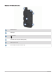
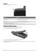

Table Of Contents
- Table of Contents
- Introduction
- inReach Features
- Viewing the Main Pages
- Connected Features
- Navigation
- Where To? Page
- Waypoints
- Saving Your Current Location as a Waypoint
- Saving a Location on the Map as a Waypoint
- Navigating to a Waypoint
- Finding a Waypoint
- Editing a Waypoint
- Deleting a Waypoint
- Changing the Photo for a Waypoint
- Increasing the Accuracy of a Waypoint Location
- Projecting a Waypoint from a Saved Waypoint
- Moving a Waypoint on the Map
- Finding a Location Near a Waypoint
- Setting a Waypoint Proximity Alarm
- Adding a Waypoint to a Route
- Repositioning a Waypoint to Your Current Location
- Routes
- Recordings
- Courses
- Weather
- Main Menu Applications
- Customizing the Main Menu
- Garmin Adventures
- Setting an Alarm
- Calculating the Size of an Area
- BirdsEye Imagery
- Camera and Photos
- Dog Tracking
- Using the Flashlight
- Geocaches
- Using the inReach Remote
- Marking and Starting Navigation to a Man Overboard Location
- Selecting a Profile
- Setting a Proximity Alarm
- Satellite Page
- Sending and Receiving Data Wirelessly
- Using the VIRB Remote
- Customizing the Device
- Custom Data Fields and Dashboards
- Rotating the Screen
- Setup Menu
- System Settings
- Display Settings
- Bluetooth Settings
- Wi‑Fi Settings
- Routing Settings
- Turning On Expedition Mode
- Setting the Device Tones
- Camera Settings
- Geocaching Settings
- Wireless Sensors
- Fitness Settings
- Marine Settings
- Menu Settings
- Position Format Settings
- Changing the Units of Measure
- Time Settings
- Accessibility Settings
- Profiles
- Resetting Data and Settings
- Device Information
- Appendix
- Index

Table of Contents
Introduction......................................1
Device Overviews.................................... 1
Montana 700i/750i Device
Overview...............................................1
Montana 700 Device Overview........... 2
Status LED........................................... 3
Installing the Lithium-ion Battery........... 3
Charging the Battery Pack.................. 4
Charging the Device More Quickly..... 4
Long-Term Storage............................. 4
Using the Power Button.......................... 5
Viewing the Status Page..................... 5
Adjusting the Backlight....................... 5
Using the Touchscreen........................... 5
Locking the Touchscreen................... 5
Unlocking the Touchscreen................ 5
Activating the Device.............................. 6
Iridium Satellite Network.....................6
Acquiring Satellite Signals...................... 6
Status Icons......................................... 7
inReach Features..............................7
Messages................................................ 7
Sending a Preset Message................. 7
Sending a Text Message.....................8
Replying to a Message........................ 8
Checking for Messages...................... 8
Viewing Message Details....................8
Navigating to a Message Location.... 8
Including Location Coordinates in a
Message...............................................9
Deleting Messages.............................. 9
Messages Settings.............................. 9
Tracking................................................... 9
Starting Tracking................................. 9
Stopping Tracking............................... 9
Sharing Your MapShare Web Page.... 9
inReach Tracking Settings.................. 9
SOS.........................................................10
Initiating an SOS Rescue...................10
Sending a Custom SOS Message.... 10
Canceling an SOS Request............... 11
Testing the Device.................................11
Syncing inReach Data........................... 11
Contacts................................................ 11
Adding a Contact............................... 11
Editing a Contact............................... 11
Deleting a Contact............................. 11
Data Use and History............................ 11
Viewing Plan Details......................... 12
Viewing Data Use.............................. 12
Viewing the Main Pages................. 12
Map........................................................ 12
Navigating with the Map................... 12
Map Page Settings............................ 12
Compass................................................13
Navigating with the Compass.......... 13
Compass Settings............................. 14
Trip Computer....................................... 15
Trip Computer Settings..................... 16
Altimeter................................................ 16
Altimeter Plot Settings...................... 16
Connected Features....................... 17
Connected Feature Requirements....... 17
Pairing a Smartphone with Your
Device.................................................... 18
Phone Notifications.......................... 18
Connecting to a Wireless Network.......18
Setting Up Wi‑Fi Connectivity........... 18
Connect IQ Features............................. 19
Downloading Connect IQ Features.. 19
Downloading Connect IQ Features
Using Your Computer........................ 19
Garmin Explore...................................... 19
Wireless Headsets................................ 19
Pairing a Wireless Headset with Your
Device.................................................19
Disconnecting or Removing a Wireless
Headset.............................................. 20
Navigation...................................... 20
Where To? Page.................................... 20
Navigating to a Destination.............. 20
Finding an Address........................... 20
Finding a Location Near Another
Location............................................. 21
Waypoints.............................................. 21
Saving Your Current Location as a
Waypoint............................................ 21
Table of Contents i