
FAA Approved Airplane Flight Manual Supplement

190-00716-03 Rev. 3 Hawker Beechcraft B300 and B300C King Air
FAA APPROVED Page 23 of 139
DATALINK WEATHER (XM OR GFDS WEATHER)
Datalink weather information displayed by the G1000 system is limited to supplemental use only. XM or
Garmin Flight Data Service (GFDS) weather data is not a source of official weather information. Use of
the NEXRAD, PRECIP, XM LTNG and DL LTNG (Datalink Lightning) data on the MAP – NAVIGATION
MAP, MAP – XM WEATHER DATA LINK or MAP – GFDS WEATHER DATA LINK pages for hazardous
weather, e.g., thunderstorm, penetration is prohibited.
NEXRAD, PRECIP, XM LTNG and DL LTNG information on the MAP – NAVIGATION, MAP – XM
WEATHER DATA LINK, or MAP – GFDS WEATHER DATA LINK pages is intended only as an aid to
enhance situational awareness of hazardous weather, not penetration. It is the pilot’s responsibility to
avoid hazardous weather using official weather data sources and the airplane’s in-flight weather radar.
OPTIONAL L3 COMMUNICATIONS AVIONICS SYSTEM WX-500 STORMSCOPE
Stormscope lightning information displayed by the G1000 system is limited to supplemental use only.
The use of the Stormscope lightning data on the MAP – NAVIGATION MAP and/or MAP –
STORMSCOPE page for hazardous weather (thunderstorm) penetration is prohibited. Stormscope
lightning data on the MAP - NAVIGATION or MAP – STORMSCOPE page is intended only as an aid to
enhance situational awareness of hazardous weather, not penetration. It is the pilot’s responsibility to
avoid hazardous weather using official weather data sources and the airplane’s weather radar.
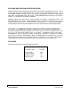
PLACARDS
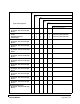
On Instrument Panel above the Standby Attitude Indicator:
STANDBY ALT/AS
ALTITUDE – FEET V
MO
-KIAS
S.L TO 21,000 263
21,000 TO 25,000 242
25,000 TO 30,000 217
ABOVE 30,000 194