
Pilot's Guide


Garmin G1000 Pilot’s Guide for the Beechcraft C90A/GT/GTi
190-00663-03 Rev. A562
APPENDIX A
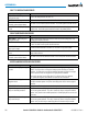
Message Comments
TRAFFIC FAIL
– Traffic device has
failed.
The system is no longer receiving data from the traffic system. The traffic device
should be serviced.
STRMSCP FAIL
– Stormscope has
failed.
Stormscope has failed. The G1000 system should be serviced.
FAILED PATH
– A data path has failed. A data path connected to the GDU or the GIA 63/W has failed.
MAG VAR WARN
– Large magnetic
variance. Verify all course angles.
The GDU’s internal model cannot determine the exact magnetic variance for
geographic locations near the magnetic poles. Displayed magnetic course angles may
differ from the actual magnetic heading by more than 2°.
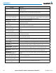
SCHEDULER [#]
– <message>. Message criteria entered by the user.
SVT
– SVT DISABLED: Out of available
terrain region.
Synthetic Vision is disabled because the aircraft is not within the boundaries of the
installed terrain database.
SVT
– SVT DISABLED: Terrain DB
resolution too low.
Synthetic Vision is disabled because a terrain database of sufficient resolution (9 arc-
second or better) is not currently installed.
CHECK CRS
– Database course for
LOC1 / [LOC ID] is [CRS]°.
Selected course for LOC1 differs from published localizer course by more than 10
degrees.
CHECK CRS
– Database course for
LOC2 / [LOC ID] is [CRS]°.
Selected course for LOC2 differs from published localizer course by more than 10
degrees.
[PFD1, PFD2, or MFD1]
CARD 1 REM
– Card 1 was removed. Reinsert card.
The SD card was removed from the top card slot of the specified PFD or MFD. The SD
card needs to be reinserted.
[PFD1, PFD2, or MFD1]
CARD 2 REM
– Card 2 was removed. Reinsert card.
The SD card was removed from the bottom card slot of the specified PFD or MFD. The
SD card needs to be reinserted.
[PFD1, PFD2, or MFD1]
CARD 1 ERR
– Card 1 is invalid.
The SD card in the top card slot of the specified PFD or MFD contains invalid data.
[PFD1, PFD2, or MFD1]
CARD 2 ERR
– Card 2 is invalid.
The SD card in the bottom card slot of the specified PFD or MFD contains invalid data.
TRN AUD FAIL
– Trn Awareness audio
source unavailable.
The audio source for terrain awareness is offline. Check GIA1 or GIA 2.
TERRAIN AUD CFG
– Trn Awareness
audio config error. Service req’d.
Terrain audio alerts are not configured properly. The system should be serviced
HOLD EXPIRED
– Holding EFC time
expired.
Expect Further Clearance (EFC) time has expired for the User Defined Hold.
BARO MISMATCH
– Correct baro
mismatch for VNAV guidance.
Altimeter setting is not the same on PFD1 and PFD2. Synchronize settings for VNAV
guidance.
TERRAIN DISABLED – Terrain
Awareness DB resolution too low.
TAWS is disabled because a terrain database of sufficient resolution (9 arc-second or
better) is not currently installed.
GDU ZOOM LIMITED – Map zoom
has been automatically limited.
Increases in map range are automatically limited at > 68 degrees 35 minutes north or
south.
CURSOR LIMITED – Map panning
limit has been reached.
Map cursor panning is limited to < 89 degrees north or south.