
Pilot's Guide


Garmin G1000 Pilot’s Guide for the Beechcraft C90A/GT/GTi
190-00663-03 Rev. A384
HAZARD AVOIDANCE
6.6 TRAFFIC INFORMATION SERVICE (TIS)
WARNING: Do not rely solely upon the display of traffic information to accurately depict all of the traffic
information within range of the aircraft. Due to lack of equipment, poor signal reception, and/or inaccurate
information from other aircraft, traffic may be present but not represented on the displays.
NOTE: TIS is available only when the aircraft is within the service volume of a TIS-capable terminal radar
site. Aircraft without an operating transponder are invisible to Traffic Advisory Systems (TAS), Traffic Alert
and Collision Avoidance Systems (TCAS), and to TIS. Aircraft without altitude reporting capability are shown
without altitude separation data or climb descent indication.
NOTE: TIS is disabled if another traffic system is installed.
Traffic Information Service (TIS) is designed to help in detection and avoidance of other aircraft. TIS uses the
Mode S transponder for the traffic data link. TIS receives traffic information from ground stations, and is updated
every five seconds. The system displays up to eight traffic targets within a 7.5-nm radius, from 3000 feet below
to 3500 feet above the requesting aircraft. The system displays traffic using the symbology shown in Table 6-12.
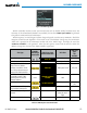
Traffic Symbol Description
Non-Threat Traffic
Traffic Advisory (TA)
Traffic Advisory Off Scale
Table 6-12 TIS Traffic Symbols
Traffic Advisories (TA) alert the crew to intruding aircraft. When traffic meets the advisory criteria for the TA,
a solid yellow circle symbol is generated. A TA which is detected but is outside the range of the map on which
traffic is displayed are indicated with a message in the lower left corner of the map.
TIS also provides a vector line showing the direction in which the traffic is moving, to the nearest 45°. Traffic
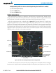
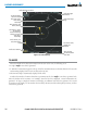
information for which TIS is unable to determine the bearing (non-bearing traffic) is displayed in the center of the
Traffic Map Page (Figure 6-103) or in a banner at the lower left corner of maps other than the Traffic Map Page on
which traffic can be displayed (Figure 6-99).
The altitude difference between the requesting aircraft and other intruder aircraft is displayed above/below the
traffic symbol in hundreds of feet. If the other aircraft is above the requesting aircraft, the altitude separation
appears above the traffic symbol; if below, the altitude separation appears below. Altitude trend is displayed as
an up/down arrow (for speeds greater than 500 fpm in either direction) to the right of the target symbol. Traffic
symbols for aircraft without altitude reporting capability appear without altitude separation or climb/descent
information.