
Pilot's Guide


Garmin G1000 Pilot’s Guide for the Beechcraft C90A/GT/GTi
190-00663-03 Rev. A368
HAZARD AVOIDANCE
DISPLAYING TAWS-B DATA
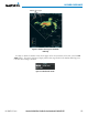
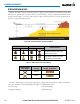
TAWS-B uses yellow (caution) and red (warning) to depict terrain and obstacles (with heights greater than
200 feet above ground level, AGL) alerts relative to aircraft altitude. Colors are adjusted automatically as the
aircraft altitude changes. The colors and symbols in figure and tables below are used to represent terrain,
obstacles, and potential impact points.
Figure 6-80 Terrain Altitude/Color Correlation for TAWS-B
Unlighted Obstacle Lighted Obstacle
Obstacle Location
< 1000’ AGL > 1000’ AGL < 1000’ AGL > 1000’ AGL
Red obstacle is above or within 100 ft
below the aircraft altitude
Yellow obstacle is between 100 ft and
1000 ft below the aircraft altitude
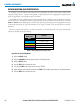
Table 6-7 TAWS-B Obstacle Colors and Symbology
Potential Impact
Point Symbol
Alert Type Example Annunciation
Warning
Caution
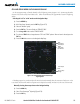
Table 6-8 TAWS-B Potential Impact Point Symbols with Alert Types
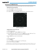
The Map - TAWS-B Page is the principal map page for viewing TAWS-B information. TAWS-B information
can be also displayed on the following maps and pages as an additional reference:
• PFD Inset Map
• Navigation Map Page
• Trip Planning Page
• Flight Plan Page